Colorado Aquifers
An aquifer is a groundwater reservoir composed of geologic materials that are saturated with water and sufficiently permeable to yield water in a usable quantity to wells and springs. Sand and gravel deposits, sandstone, limestone, and fractured crystalline rocks are examples of geologic materials that form aquifers.
Aquifers provide two important functions: They transmit groundwater from areas of recharge to areas of discharge, and they provide a storage medium for groundwater.
Groundwater in Colorado occurs in different aquifer types, with the most common being:
- Alluvial aquifers composed of unconsolidated granular sediments
- Sedimentary aquifers composed of consolidated and semi-consolidated granular sedimentary bedrock formations
- Fractured crystalline rock aquifers composed of volcanic materials
The distribution of Colorado’s aquifers depends on local geology and geographic setting. The state’s diverse geology is characterized in some places by sedimentary formations created by erosion and the windblown deposition of sediment and in others by crystalline rocks formed by past uplift and volcanic activity. Surface water drainage patterns further divide the state into eight major watersheds, each with its own characteristics.
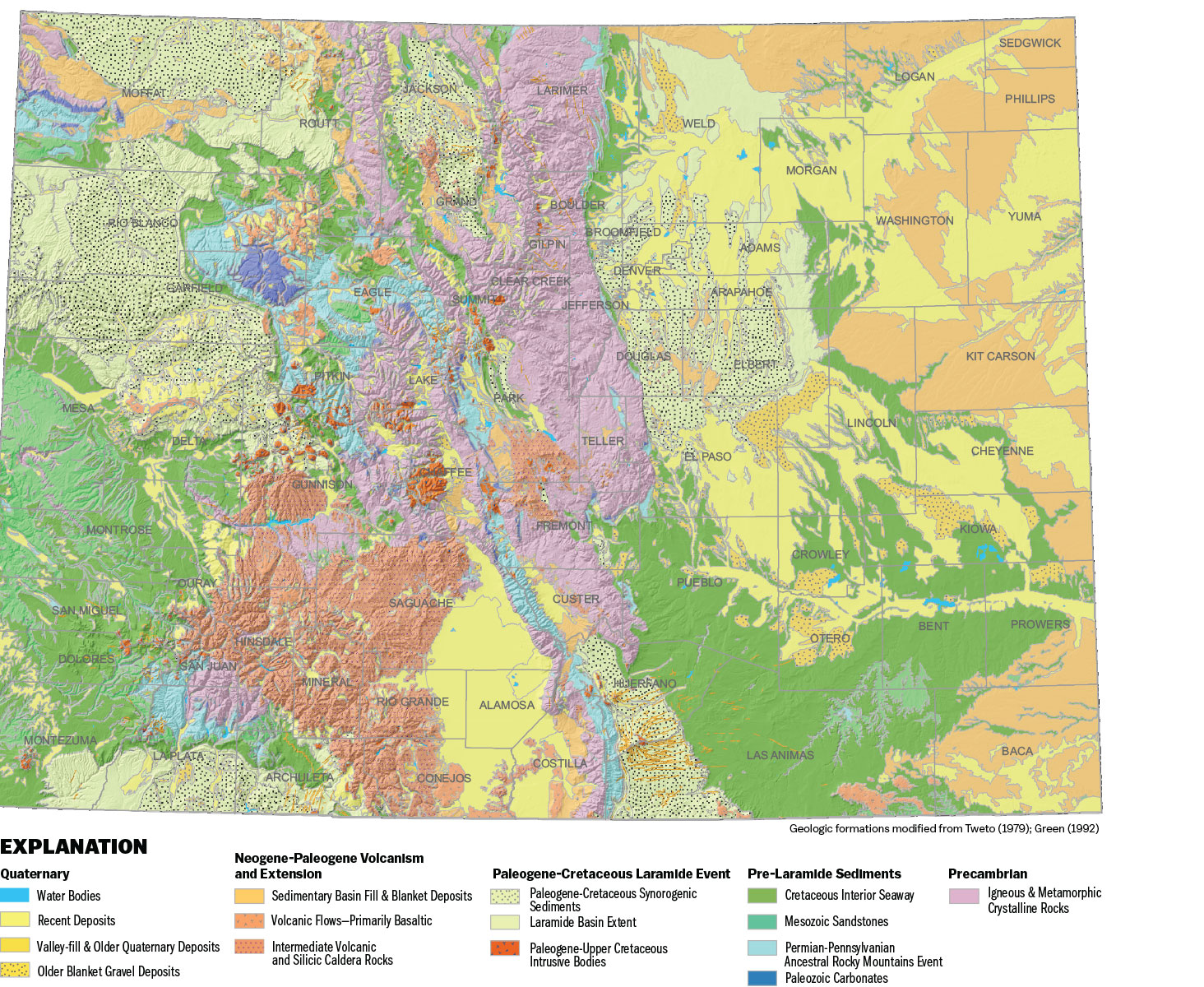
This generalized geologic map of Colorado shows Colorado’s major geologic formations classified by age. Rocks and sediments in Colorado tell a complex tale stretching back nearly 3 billion years. Courtesy Colorado Geological Survey
Rocks and sediments in Colorado tell a complex tale stretching back nearly 3 billion years. The table below lists major events from the geologic record in chronological order, with youngest at the top and oldest at the bottom, to convey how the formations may stack on top of each other. The table also summarizes the types of rocks preserved as well as the types of aquifers those rocks form.
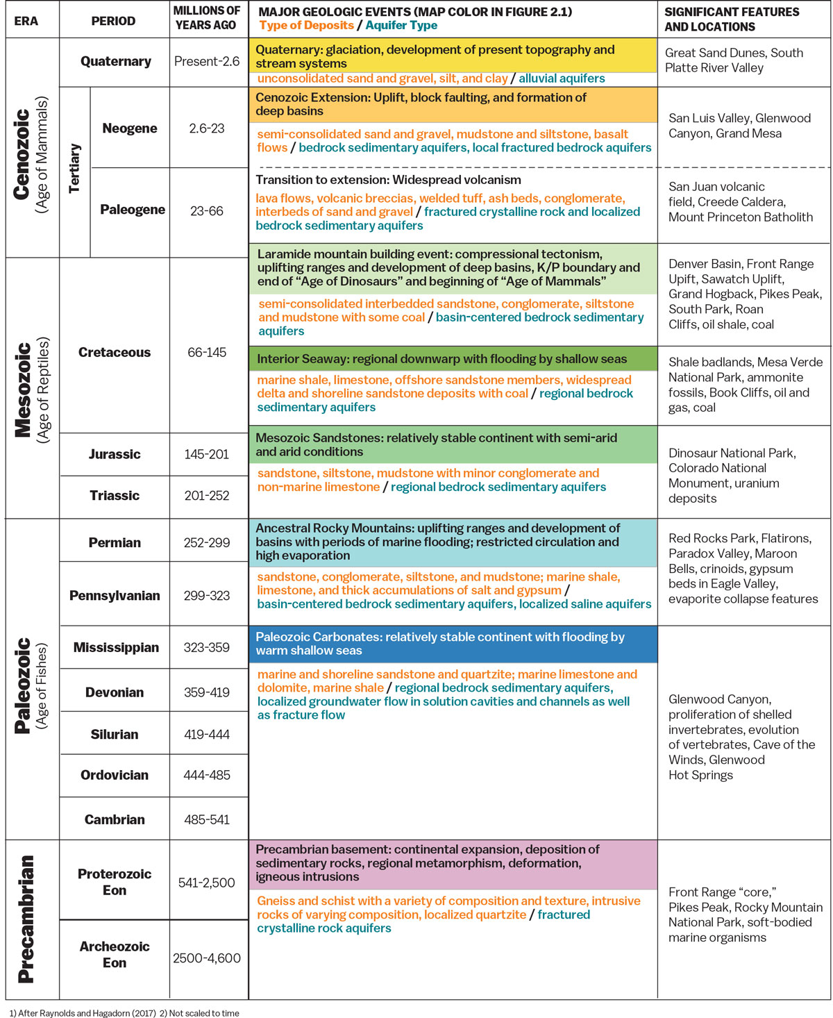
Courtesy Colorado Geological Survey
Aquifers Around the State
There are numerous named aquifers of varying types all over Colorado. Here are some that show the range of aquifer types and demands on their resources.
South Platte Alluvial Aquifer
A vast tributary aquifer that ranges from 20 feet deep under Denver to 200 feet deep 160 miles downstream in eastern Colorado, the South Platte Alluvial Aquifer contains about 8.3 million acre-feet of water, and it feeds—and is fed by—return flows from South Platte River diversions.
San Luis Valley Aquifers
Home to a shallow unconfined aquifer whose flows are connected to the Rio Grande and a deeper confined aquifer beneath it, groundwater in the confined aquifer occurs under almost half of the valley and is tapped by deep wells with some from 1,000-2,000-feet deep, and others deeper. Water in the unconfined aquifer can be found at 12 feet or less below the surface of about half of the valley, though in places, wells reach more than 300 feet below the surface. More than 3,000 wells operate in the San Luis Valley, irrigating one of the top three farming regions in Colorado—most wells tap the unconfined aquifer.
Denver Basin Aquifers
This system consists of four aquifers underlying a 6,500 square-mile area from Greeley to Colorado Springs and from Limon to Jefferson County: the Dawson, Denver, Arapahoe and Laramie-Fox Hills aquifers. Water is found in sandstone beds, often as much as a half-mile below the surface. Natural recharge is very slow, making them essentially nonrenewable. Water in each of the four Denver Basin bedrock aquifers is allocated to overlying landowners at a withdrawal rate of 1% per year for up to 100 years or until exhausted, whichever occurs first.
High Plains Aquifer
Often called the Ogallala Aquifer, the High Plains Aquifer underlies about 174,000 square miles of the central United States from South Dakota to Texas and New Mexico, including about 14% of Colorado. Its waters are critical to eastern Colorado’s agricultural economy, but the aquifer is being depleted at an unsustainable rate. The Colorado Division of Water Resources estimates that farmers in eastern Colorado have drained an average of 850,000 acre-feet of water from the aquifer every year since large-scale pumping began in the mid-20th century.
