This year, the first-ever Colorado River Drought Contingency Plan is set to launch, and water officials expect 2020 to bring unprecedented changes to the way the river is run, including cutbacks in water use by some states.
Drought and climate change are expected to play a leading role in determining how to reduce water use and bring the stressed river system into a sustainable, balanced state of being.
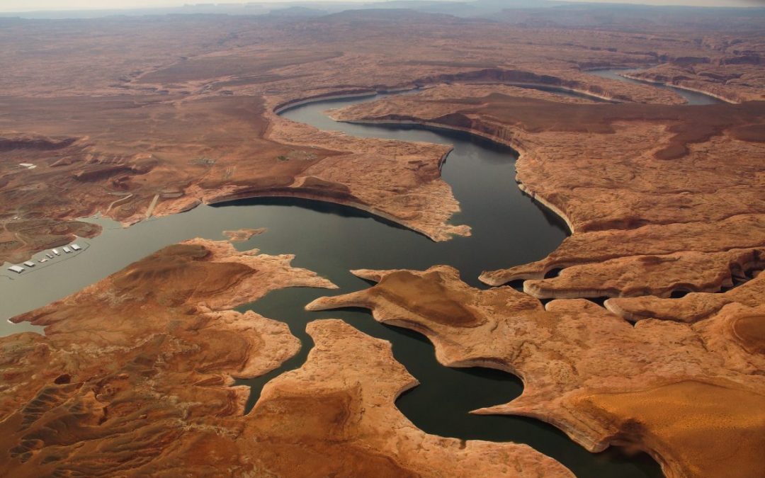
After historically low levels were reached last year in Lakes Powell and Mead, Arizona and Nevada are now poised to implement their first-ever cuts in water diversions, while Colorado and the other upper basin states are working to explore ways to conserve water and bank it in Lake Powell’s new drought pool to avoid future shortages.
Brad Udall, a senior climate scientist at Colorado State University’s water center, said the river’s operations are set for a major rework.
2019, he said, was “a really big [water] year, so I think everybody’s happy, but to think somehow the drought is over and climate change isn’t happening—or to hope for the best and ignore the lessons of the last 19 years—I think these high temperatures will remind people, ‘This is not the same old game we used to play in the 20th century.’”
A look back
A lot has changed since the Colorado River Compact first divvied up the river’s waters in 1922. Today, more than 40 million people in two countries rely upon the river, which originates on the Western Slope of the Rocky Mountains in northern Colorado, and is fed by major tributaries like the Green, Gunnison and San Juan rivers. Cities from Denver to San Diego, though geographically outside of the natural river basin, divert water from the river for drinking and industry, and farmers irrigate 5.5 million acres of everything from alfalfa to melons.
The Colorado River Basin is also now more than 2 degrees Fahrenheit warmer than the twentieth century average—with “hotter” droughts depleting river flows. By necessity, as the climate continues to change, bringing continued warming and drying, shortage-sharing agreements on the river must continuously be updated to keep changing, too. The Drought Contingency Plan (DCP) was needed as a stop-gap until a new set of operating guidelines, due by 2026, are written.
The DCP’s predecessor
The DCP’s origins lie with the Colorado River Interim Guidelines. Written in 2007, the operating guidelines were designed to address the Colorado River’s deteriorating storage levels. They identify how to operate the river’s two major reservoirs, Lake Powell and Lake Mead, under hotter, drier conditions, and to share the risk of shrinking water supplies between the upper and lower basins.
But the 2007 interim guidelines, while temporarily keeping the basin out of crisis, did not anticipate the extent of drought that the basin would experience. In 2013, then-Secretary of the Interior Sally Jewell directed states to consider additional measures or face unilateral federal action to avoid a potential crisis. With its own interests to protect, including water deliveries to contractors and tribal water rights, the federal government needed states to put a more robust plan in place.
That led to the latest temporary plan, the DCP, which negotiators say provides some security in avoiding a potential crash of the Colorado River system.
Six years in the making, the DCP includes two plans, hammered out separately by the lower and upper basin states. The upper basin plan focuses on flexibility in reservoir operations during drought conditions, investigating how to reduce water demands—including with voluntary water conservation programs—and weather modification to augment precipitation. In the lower basin, the process needed to move more quickly because water use already exceeds allocations. Cities and farms in Arizona, California and Nevada agreed to scale back and take deeper cuts as Lake Mead reaches threshold elevations that trigger those cutbacks. This summer, the first threshold was triggered, so Arizona and Nevada will implement their cutbacks this year.
Developing plans for each basin was tricky considering that within each state there are also individual tribes, competing interests, and conflicts between urban and rural water users. But, pushed by a deadline from U.S. Bureau of Reclamation Commissioner Brenda Burman, in March 2019, the seven states asked Congress to provide necessary authorizations to execute their final plans. In an era when Congress spends much of its time at an impasse, legislators on both sides of the aisle recognized the need for drought planning. In April, federal legislators passed the Colorado River Drought Contingency Plan Authorization Act and the following month, on May 20, representatives from the seven basin states and Department of the Interior signed completed upper and lower basin drought contingency plans.

Colorado River Basin: Credit: Chas Chamberlin
Not a new problem
As Eric Kuhn and John Fleck write in their new book, “Science Be Dammed: How Ignoring Inconvenient Science Drained the Colorado River,” even during compact negotiations in the 1920s, records showed the river’s annual flows were lower than the total 17.5 million acre-feet allocated to the seven states and Mexico. In fact, three different studies during the 1920s estimated natural river flows at Lee Ferry at between 14.3 million acre-feet and 16.1 million acre-feet.
Planners chose to ignore that information, Fleck says, and with it, they ignored convincing evidence showing the basin regularly experienced long periods of drought. “We have rules written down on paper, allocating water across the basin, that essentially allocate more water than the river actually has—and this manifests itself quite differently in the lower basin than the upper basin,” says Fleck, director of the Water Resources Program at the University of New Mexico. Fleck’s co-author Kuhn is the now-retired general manager of the Colorado River Water Conservation District.
In the lower basin, California, Nevada and Arizona have long overused their share of the river (approximately 7.5 million acre-feet annually, averaged over 10-year rolling cycles), Fleck says, whereas the upper basin states have yet to use more than around 4 million acre-feet (of the “remaining” 7.5 million acre-feet originally intended, but not necessarily guaranteed, for them). But everyone needs to come to terms with the fact that there is less water in the basin, Fleck says. “And that’s what the DCP is,” he says. “The first steps toward a long-term plan for everyone to use less water.”
Today, Kuhn and Fleck note, the river’s average flow between 2000 and 2018 has been only 12.4 million acre-feet—16 percent lower than the 1906-2017 average of 14.8 million acre-feet per year.
To use less water, the two basins need their own strategies. In the lower basin, the DCP sets rules to scale back use of lower basin allocations as Lake Mead drops, or until storage conditions improve. Arizona, Nevada and Mexico will see cuts this year, while California could follow in future years if reservoir storage declines continue. Over the past few years, water users already started scaling back voluntarily, and, says Fleck, “The DCP gives the structure that gives us the confidence [the cutbacks] will continue,” he says.
The upper basin occupies a precarious position of its own, even though it uses less water than it technically could under the compacts that govern its use—use in the upper basin has remained flat, at around 4 million acre-feet per year, since 1990. Because upper basin states must not interfere with a specific quantity of water flowing downstream, they’ll take on much of the burden of dealing with declining flows in a warmer future, Fleck adds. “That means the upper basin has to be sure it has the tools in place to make sure it can continue to meet its compact obligations, to send water out of Lake Powell,” he says. “And it may have to figure out how to conserve water below 4 million acre-feet.”
Challenges of a warming world
Any planning on the Colorado River—from the crops farmers plant, to the ways in which cities incentivize conservation among customers, to the DCP’s successor—must address the fact that the basin is facing a hotter, drier future.
Rainfall records, reconstructed from tree ring chronologies that stretch back more than a thousand years, reveal past patterns of southwestern droughts, marked by dry conditions associated with natural climate variability. Today’s droughts in the basin are different. They are notable not just for a lack of precipitation, but also for warmer temperatures, which spur changes in snowpack, increase transpiration in forests and fields, and boost evaporation from reservoirs.
The U.S. Global Change Program’s Fourth National Climate Assessment in 2018 painted a troublesome picture of reduced water supplies and future food insecurity in the region. It also identified risks to southwestern tribes from drought and wildfire, and challenges to the region’s infrastructure and energy supplies.
More localized studies of the Colorado River Basin also show that as climate change continues to heat and dry the region, the river’s flows will keep dropping. A 2017 study by Brad Udall, a senior water and climate research scientist at the Colorado Water Institute at Colorado State University and Jonathan Overpeck, dean of the School for Environment and Sustainability at the University of Michigan, showed that flows between 2000 and 2014 averaged 19 percent below the 1906-1999 average, with one-third of those losses due to higher temperatures, versus changes in precipitation. If warming continues, according to that 2017 study, Colorado River flows could decline by 20 to 35 percent by 2050 and 30 to 55 percent by the end of the century.
A study published the following year by Udall and others reiterated that “unprecedented basin-wide warming” was responsible for the declines, this time looking at 1916 through 2014, when the river’s flows dropped by 16.5 percent during that period, even though annual precipitation had increased slightly. The study also revealed the entire basin’s sensitivity to shifts in precipitation patterns—that it matters whether precipitation comes as rain or snow, and also where it falls. Snowfall in the upper basin is more beneficial to the system, for example, than rainfall in southern Arizona. And the future doesn’t look promising: The 2018 study forecasts a future decline in snowfall within four sub-basins in Colorado.
Healthier snowpack this past winter offered everyone a bit of a reprieve, but the Colorado River Basin’s problems aren’t over. At the end of the water year, total system storage was at only 53 percent, according to Reclamation, though that’s up from just under 47 percent in October 2018.
An earlier version of this article appeared in the Fall 2019 issue of Headwaters magazine.
Fresh Water News is an independent, non-partisan news initiative of Water Education Colorado. WEco is funded by multiple donors. Our editorial policy and donor list can be viewed at wateredco.org.
 Print
Print