…A Calculation of Risk, Reward, and Restitution in Flood Zones
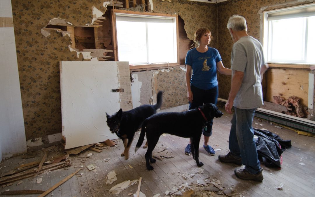
The downtown Lyons bungalow that Bonnie-Sue Hitchcock and her partner Chris Todd purchased in 2011 was built 100 years ago. A modest home sited mere blocks from the picturesque south fork of St. Vrain Creek, its location provided everything that was important to the couple: walking access to downtown Lyons, proximity to the schools for Bonnie-Sue’s teenage daughter, and a diverse community of artists, professionals, laborers and immigrants. The nearby creek offered cool relief in the dog days of summer. The riparian vegetation was home to songbirds, small furry creatures, foxes and coyotes. Living close to the water provided connection to the natural world, paramount to a family hailing from Alaska who feels more at home in the rugged wilderness than in suburbia.
Sure, they knew they were living in a floodplain. They’d researched and purchased flood insurance in order to qualify for a mortgage. But the fact that the home sat in the middle of a high-risk zone seemed to contradict the reality of their quotidian life. Theirs were sunny days, warm and arid.
We know what happened next. For five days in September 2013, historic flooding swept through the Front Range. Some of the hardest-hit communities included Jamestown, Longmont, Glen Haven, Estes Park, Evans— and, of course, Lyons.
As the South St. Vrain Creek carved a path through the front of Hitchcock’s house, the North St. Vrain tore through the neighborhoods behind. The two branches united and, as Hitchcock says, “went ballistic.” The mud filled her home waist deep. Doors were torn from doorjambs. Trees the width of three grown men uprooted from the swollen earth.
When the floods subsided, Hitchcock and Todd—like hundreds in their situation—emptied their house of mud. But despite their best efforts, mold sprouted, the house remained uninhabitable, and six months later they were forced to tear down the remains and begin building anew. Days before the demolition, Bonnie-Sue gazed at her home’s gutted interior: The walls and floor stripped of drywall and floorboards, all that remained was the lumber frame, exposed wires and a bedrock of deep, brown dirt. “I knew we were in a flood zone,” she says. “But I never thought it would flood like this. Of course it wouldn’t. We live in Colorado.”
National Flood Insurance Program
For millennia, communities have lived along rivers. This is where the soil is fertile and where transport comes easily. Riparian areas are scenic and bucolic, and even in the modern technological age, where we get our food from the grocery store and rarely travel by waterway, communities tend to congregate nearby a river’s edge. Hitchcock and Todd have decided to rebuild their house in the exact location, in part because “it’s the best place to live,” says Todd.
They’re not naïve. Because they live in a designated 100-year floodplain, they understand there is a 1 percent chance of another flood sweeping through—each year. They accepted the cost of purchasing the required flood insurance when they bought the home, and they will rebuild in accordance with more stringent building codes in order to once again qualify for the insurance. Their home will be raised 4 feet, and its new foundation will be better designed to withstand a flood. Still, because of the risk they assume, they will pay a premium to continue living near the banks of the St. Vrain.

For the Colorado Water Conservation Board’s Kevin Houck, the pace hasn’t slowed in the nine months following September 2013’s flood in the scramble to help communities like Jamestown (above) update flood hydrology information, revise floodplain maps, enforce floodplain building codes and more. Photo by: Theo Stroomer
In the late 1960s, Congress created the National Flood Insurance Program (NFIP) to safeguard against the inevitable damage caused by natural floods. The program, established by the National Flood Insurance Act in 1968, enables property owners living within designated floodplains to purchase federally backed insurance protection against flood losses. At the time, few private insurers were willing to cover flood damage, and the federal government, faced with escalating costs for disaster assistance, was looking for an alternative.
Today, standard homeowners insurance policies do not cover flood damage. For most, purchasing the additional flood insurance is optional. However, for properties that sit within a designated 100-year floodplain and have a mortgage backed by a federal agency, flood insurance is mandated. Nationwide, approximately 5.5 million properties today are insured through the NFIP. In Colorado, the Federal Emergency Management Agency (FEMA), the agency responsible for administering the NFIP, reports a total of 23,255 active policies with annual premiums totaling just under $19 million. According to Michael Gease, FEMA natural hazards specialist, flood insurance premiums in high-risk areas average about $1,000 per year but have been known to cost 15 or more times that.
Of course, insurance is all about hedging against risk. “Flood insurance is not that different from auto insurance,” says Ryan Pietramali, risk analysis branch chief at FEMA Region 8. “If you take higher risks and are more likely to incur claims, your rates are higher.” In other words, live in the floodplain, and be prepared to pay a premium. Live outside of it, and rates drop to “very affordable prices,” says Pietramali.
Although individuals outside the 100-year floodplain who live in communities participating in the NFIP can also purchase flood insurance, few do despite the lower premiums, in part because they do not perceive themselves to be at risk. After all, a floodplain map shows where a flood will occur, right? Yes, and no.
Risk: A Line on a Map
The September 2013 floods underscored that existing floodplain maps, which are established by FEMA, aren’t always accurate in their identification of risk. “Our maps offer a really good depiction of a predictable flood risk, but there is uncertainty around that line,” says Pietramali.
“That line” refers to the mapped boundary denoting the 100-year floodplain, or the high water mark for a flood that has a 1 in 100 chance of occurring any given year. FEMA labels it the high-risk Special Flood Hazard Area. “Nationally, about 25 percent of flood insurance claims come from areas outside our high-risk Special Flood Hazard Area,” says Gease. “And for the September 2013 floods, about half of all flood insurance claims came from low- to moderate-risk areas.”
A December 2013 analysis by the Denver Post showed that more than 17 percent of homes destroyed or damaged in four of the counties hardest hit by September’s flood— Weld, Larimer, Boulder and Logan—were not technically in the floodplain, according to the map. That same analysis found that some of the affected counties’ flood management plans were out of date. In some cases, floodplain maps had not been updated since 1979.
In other cases, such as in Longmont, flood maps were accurate, but the magnitude and extent of the flooding was so great, on the order of a 500-year flood, that floodwaters reached well beyond the regulatory 100-year floodplain.
In either case, the consequence is that many of the people affected by the floods did not have flood insurance. When their homes were damaged or destroyed by the floods, they relied on personal savings, emergency federal and state funding, and the help of nonprofit relief organizations to get back on their feet.
Designating a floodplain, and identifying the risk of living and building within it, is a complicated task largely undertaken by FEMA. The highest-risk area is known as a floodway and cannot be built in. The next designation is the 100-year floodplain.
The floods “gave huge insights into where we were close and where we missed the mark” with floodplain maps, says Kurt Bauer, engineering project manager with the City of Boulder’s Public Works Department. For instance, several of the drainages in Boulder County that breached and caused significant damage saw “drastically different inundation than what the maps predicted,” he says.
Immediately after the flood, officials capitalized on the opportunity to capture data using LiDAR technology, a remote sensing laser tech-nology that is used to create high-resolution maps. “With floodplain mapping, everything is theoretical,” explains Bauer. “But for the first 16 days after the flood, for 12 hours straight, we had a team documenting the flood extent and can now correlate that information with the current floodplain mapping.” This data will be used to update the floodplain maps that “we think were incorrect,” says Bauer.
Although FEMA is typically the agency in charge of updating maps, local communities “can update their map at any time, using the process to show where the channel has migrated and to show new flood risk,” says Pietramali. Then the community submits the updated map for FEMA approval.
Under national flood insurance reforms passed in 2012 and 2014, FEMA is also revamping its mapping program with the guidance of a Technical Mapping Advisory Council. The committee will review the new national flood-mapping program and ensure FEMA is utilizing “technically credible” data and mapping approaches. However, this is happening at a slow—some would say glacial—pace.

In Milliken, the confluence of the Big and Little Thompson rivers in September 2013 spewed floodwaters far exceeding FEMA’s mapped 100-year floodplain. In April 2014, the Town of Milliken approved an extended regulatory floodplain, beyond FEMA’s lines, which will impact local building codes but not the National Flood Insurance Program, which uses FEMA’s map. FEMA, too, plans to update its lines, but it could take several years. Courtesy of: CWCB and ICON Engineering, Inc.
In the aftermath of September 2013’s floods, local and state officials are scrambling to undertake their own floodplain mapping analyses, rather than waiting for FEMA, according to Kevin Houck, chief of watershed and flood protection for the Colorado Water Conservation Board (CWCB). “Communities are looking for accurate information and will need that to make plans and decisions,” says Houck.
The significance of these efforts is great; a change in designation could preclude a homeowner from rebuilding their property or could add significant expense if a redrawn boundary lands a home in a newly identified floodplain or floodway.
The boundaries impact not only flood insurance rates, but also building regulations. FEMA establishes minimum standards for building within the 100-year floodplain, and buildings must adhere to those standards to be eligible for the NFIP. However, “a community or state can always regulate to more restrictive standards than ours,” says Pietramali.
Colorado, in fact, adopted stricter floodplain management standards statewide in 2011, and the state is committed to ensuring that communities rebuild accordingly following September’s flood, says the CWCB’s community assistance program coordinator Jamie Prochno. Highlights of the standards include requiring new structures to be built at least 1 foot above the water surface elevation of the 100-year floodplain, requiring “critical facilities” like schools and hospitals to be built at least 2 feet above the floodplain, and instituting a more restrictive floodway for new flood studies.
When the standards were adopted, communities around the state were given a three-year transition period to finalize their flood ordinances, and the higher floodplain standards were being rolled out when the September 2013 flood hit. Prochno says the standards won’t change in the wake of the flood.
Higher standards reduce the risk of flood losses, which also translates to lower flood insurance premiums. For example, in Fort Collins, where city officials have undertaken significant flood mitigation steps, flood insurance policy holders in highrisk areas receive a 30 percent discount on their policies, says Gease.
Still, many residents whose homes have been destroyed find themselves in limbo while waiting for the mapping analyses to be complete. According to the Post, more than 70 properties in Larimer County may now be in the floodway and cannot be rebuilt. In Weld County’s Milliken—where Gease says the flooding exemplified the magnitude of the difference between what was mapped and what actually happened—residents of a decimated trailer park are waiting for the green light to return. The trailer park was not in the designated floodplain, although it was near the South Platte River, and none of the residents had flood insurance. Updating the town’s floodplain map could render the land a designated floodplain, and with that designation would come strict building requirements. Until that process is complete, many of the residents are in the unenviable position of choosing to move somewhere else or wait to return to their home, knowing that may not be an option.

Jamestown Mayor Tara Schoedinger is leading the charge to rebuild her flood-destroyed community and bring residents home. Photo By: Theo Stroomer
Moving more quickly than most, the tiny 300-member town of Jamestown embarked on an ambitious project to redraw its floodplain map in a period of three months—and then started rebuilding. That despite the obvious risks. After all, the flooded James Creek of September 2013 decimated Jamestown: With 26 homes destroyed and another 37 damaged, only 20 residents continued to inhabit the community after the flood. One man was killed when a massive landslide crushed his home. The town’s water supply was ravaged. With its roads and bridges washed out, the town was rendered virtually inaccessible.
But with Mayor Tara Schoedinger at the helm, Jamestown residents are determined to rebuild. Summoning the small town spirit they say distinguished the picturesque community, residents have held fundraisers, pitched in to clear out debris and damaged structures, and congregated online at rebuildjamestown.org, where links guide people to give tax-deductible donations and to follow the town’s progress.
Jamestown, which operates on an annual budget of $56,000, has since received more than $5 million toward rebuilding from FEMA and the U.S. Small Business Administration (SBA). That includes almost $1.1 million to 211 residents through FEMA’s Individuals and Households Program, and more than $2.5 million in low-interest SBA loans. The town’s post office reopened in February, and the U.S. Environmental Protection Agency has repaired damage to the stream corridor along a town park.
The remapping effort, which is guiding the rebuild, was not an idle project, says Mayor Schoedinger. “It was in response to a disaster that displaced an entire community. In order to bring people home, we needed to figure out where our post-flood, 100-year elevation is. We need to design what we are going to do in the stream corridor to protect our community from 100-year floods and from spring runoff floods.”
Not every community has coalesced into such a strong community effort, or made as much progress as Schoedinger’s. Out of the canyons downstream of Jamestown, in the prairie town of Evans, population 22,000, a predominantly Latino community is struggling to rebuild. Many Evans residents lack American citizenship, and in addition to losing their homes, they have faced the uncertainty of navigating federal assistance, fearful that attempts to secure recovery funding could lead to questions of citizenship or, worse, deportation. Unlike in Jamestown, there is no fundraising website for Evans.
Bearing the Costs of Risk
In the first six months after the September 2013 flood, more than $284 million in federal funds were provided for recovery. More than $222 million came in the form of disaster grants to individuals and families, flood insurance payments and low-interest loans to renters, homeowners and businesses. Nearly $63 million came as Community Development Block Grant funds from the U.S. Department of Housing and Urban Development (HUD) that were obligated to state and local governments’ response and recovery work. In the week marking precisely six months after the flood, HUD announced a second installment of those block grants, to the tune of $199 million. The message is clear: Most communities want to rebuild and the government assistance is there, despite the risk of a future flood of similar magnitude.
For Hitchcock’s next-door neighbors, Rick DiSalvo and his wife Bonnie, the decision to rebuild has less to do with loyalty to their property and more to do with their personal finances. “We’d like to be out of harm’s way,” says DiSalvo. “But we’re thinking about resale value. We can’t do anything with our property in this condition.” Like thousands of others, to walk away now would mean forgoing the equity in what’s left of their home and defaulting on their existing mortgage. Better to take what insurance money they can, and work on putting their house back together. For Hitchcock and Todd, whose flood-ravaged property has an assessed value less than half what it was before, insurance won’t cover the full cost of rebuilding, but it will go a long way.
Some homeowners may be able to sell their properties for fair-market value, as assessed before flood damage occurred, through a FEMA voluntary buyout program. Under the program, communities can apply through the state for a federal grant that provides 75 percent of the funds toward purchasing properties in the hardest-hit areas. Structures would be removed and, by law, the land would become permanently protected open space. Public parks could be developed and a buffer zone created to reduce risk from future floods. To date, the state and local governments have received 111 applications for projects totalling $225 million under the Hazard Mitigation Grant Program, which funds not only property acquisition but also projects such as retrofitting or elevating flood-prone structures. State officials together with FEMA will determine how many of those homeowners who are seeking a buyout will be approved based on eligibility rules—a project’s projected cost benefits must meet or exceed its costs—and available funding. So far, Colorado’s Division of Homeland Security and Emergency Management, the state entity overseeing the program, estimates $46 million is available to go toward those 111 applications. Once approved, buyouts can take up to one to three years to go through.

A torrent of converging floodwaters coursed through the South Platte River east of Greeley in September 2013, undercutting and eroding the streambank and destroying a home and barn. Photo By: Mark Goldstein
Boulder County is committed to helping the 66 homeowners who applied there obtain a buyout, says public information specialist Gabi Boerkicher. For those who don’t qualify through FEMA, the next step will be to seek funds through HUD’s Community Development Block Grants. Highest priority will be given to homes in potentially hazardous areas and “homes that probably shouldn’t have been built there in the first place,” says Boerkicher. “We’ll try to help them in some way to get their money.”
As rebuilding proceeds, some question who shoulders the responsibility—and the cost—of choosing to develop floodplains or governing whether and how such development should occur: Is it the community, the individual, the federal government or, ultimately, taxpayers nationwide?
Government intervention in the wake of natural disasters has been standard in the United States since the 1930s, when the Reconstruction Finance Corporation was given authority to make disaster loans for repair and reconstruction of certain public facilities following an earthquake and, later, other types of disasters. A flurry of separate laws designating disaster relief and mitigation authority to different agencies followed, and in 1979, FEMA was created by an executive order signed by President Jimmy Carter.
In recent years, federal spending on disaster relief has tallied into the billions as government agencies offer assistance to communities affected by floods, wildfire, drought and more. According to a 2013 report from the Center for American Progress, a Washington, D.C.- based think tank, Congress spent at least $136 billion on disaster relief between 2011 and 2013, which comes out to about $400 per household—an expensive and unsustainable amount, say the report’s authors.
Part of that spending goes to the NFIP, which has struggled with funding and solvency. Following Hurricane Katrina in 2005, the program was roughly $25 million in debt, and in 2012 Congress passed major legislation aimed at reform. FEMA was directed to raise flood insurance premiums to more accurately reflect true flood risk. For some, flood insurance rates skyrocketed, creating a feverish backlash.
In response, Congress scaled back some provisions of the 2012 law with the passage of the Homeowner Flood Insurance Affordability Act of 2014. The new legislation repeals a provision in the 2012 law that threatened hundreds of thousands of homeowners with huge premium increases due to changes in risk status under updated government flood maps. Those homeowners continue to benefit from below-market rates subsidized by other policyholders, and the new legislation will preserve their grandfathered status. The measure also gives relief to people who bought homes after the changes were enacted in July 2012 and faced sharp, immediate jumps in premiums to insure older homes that did not conform to new building codes; they will see those increases rolled back.
Whether or not such insurance premium reforms lead to a more stable NFIP, flood hazard mapping itself could be further improved. Brian Varella, chair of the Colorado Association of Stormwater and Floodplain Managers, believes that now that the immediate crisis has passed, Colorado should study and consider adopting some of the precautions implemented in the similarly rugged state of Vermont in the wake of 2011’s Hurricane Irene. For instance, after Irene, which destroyed more than 500 miles of roads and more than 30 bridges, Vermont created erosion buffer zones beyond its standard floodplain lines to recognize the hazards associated with a stream’s “ancient meander areas.” Put another way: When a river is flooding, it’s likely to erode streambanks and revert to original or unpredictable channels, and any structures in the way are at high risk. This is what happened in the Big Thompson and St. Vrain drainages in September 2013 and is one reason the total destruction was so great, says Varella.
Even with improved mapping, however, individuals choosing to live in the 100-year floodplain are choosing to accept a certain level of risk, says FEMA’s Pietramali. The majority of people, he says, acknowledge the risk of living in a floodplain even as they are stunned at the damage that can occur when a flood comes.
“How do you get people to understand risk and act upon that knowledge?” Pietramali asks. “There is no easy way. We have to increase the awareness of flood risks nationwide. We have to show them case studies and build floodplain and risk maps that resonate so people understand how to use them.”
Yes, state, federal and municipal governments must educate citizens and share information, says City of Boulder’s Bauer, but they need to simultaneously urge individuals to consider the choices they’re making. “There’s a perception that the government will swoop in and save people or prevent their house from flooding or pull their car out of a creek,” he says. “And, sometimes, that happens. There are the pictures of the National Guard evacuating Lyons. But the bottom line is that people need to know about the community they live in.”
Specifically, residents should understand there are 15 major drainage ways in Boulder County and that the county has a multi-hazard mitigation plan—“Read it,” Bauer urges. In addition, people should think twice before choosing to rebuild in an area where the flood hazard remains. “Do you really want to reconstruct your basement with another $80,000 when it is in the middle of the floodplain?” he asks. “There’s a concept of repetitive loss and we need to ask if that’s responsible—for us as individuals, for the environment, for everything. Does it make sense?”
To Mayor Schoedinger and the Jamestown community, the answer is unequivocal. “This wasn’t a disaster we could have ever predicted or imagined,” she says. “And while there’s a good chance we are going to have big events like this in the future, we can do our best to protect our community and do everything we can to make it safer. Yes, we live in steep canyons and have wide channels and there is debris that can wreak havoc. But we will rebuild because Jamestown is the most special community where a person could live. I cannot imagine future generations not having the opportunity to live here.”
Not everyone is so certain, as evidenced by the plight of Hitchcock and Todd, the DiSalvos, and countless others whose mortgages now exceed their property value.
“Would we walk away if we could?” asks Hitchcock, who is now in the process of rebuilding. “Quite possibly. But we can’t afford to. Almost all of our money is locked up in the house. If we left, we’d have nothing.
 Print
Print