The Future of Oil Shale Development in the White River Basin
To squeeze the stone of oil shale, I had parked the car along Piceance Creek Road. Piceance Creek itself flowed by about 100 yards away as I walked to a road cut where deposits were exposed. Three miles downstream from here, the creek would join the rippling currents of the White River. It was quitting time in the gas fields, and big trucks and pickups hurtled past, crowding the pavement on a country road built for the occasional needs of local ranchers traveling to Meeker, Colo., 15 miles away.
The natural gas boom of the past decade had turned this once-pastoral region of northwestern Colorado into a maze of giant pipelines, warehouses, and house-sized air compressors sealed off by chain-link and barbed-wire fences. At the time of my visit in the summer of 2008, the derricks of several dozen drill rigs sprouted amid the rolling hills of sagebrush, greasewood and piñon pine.
Follow almost any gravel road in this remote part of the White River Basin, and suddenly, around a bend, would be some facet of industrialized energy extraction—perhaps with a herd of wild horses nearby. Here in hidden Colorado was a boom of immense proportions. Officials said it was only beginning. And oil shale, the reason for my trip, could dwarf what had so far occurred.
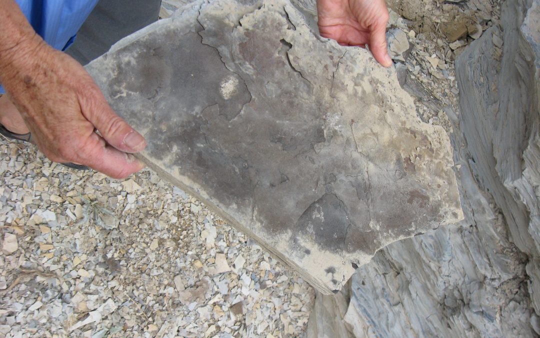
“You can see the mahogany marker in the rock,” Frank Cooley said when he directed me to the road cut. The mahogany marker, as the practicing water lawyer and trained geologist described it, was a layer of whitish volcanic ash several inches thick atop the mahogany layer itself. Mahogany is the richest of eight zones of kerogen—the precursor to oil and gas.
“You can smell it in the rock,” Cooley said. Sure enough, when I cracked a piece of the shale open, it reminded me of an ashtray, grimy after a night of snubbed cigarettes.
A rich source of petroleum
Since at least 1916, Coloradans, along with the rest of the nation, have talked about oil shale. Technically, the rock is not shale, and the kerogen is not oil. The smelly substance began to form around 6 million years ago from rich organic material at the bottom of an ancient sea called Lake Uinta.
In another several million years from now, the shale might succumb to the Earth’s heat and pressure to produce oil like that which has flowed so plentifully from beneath the sands of Saudi Arabia. But today, people exert the necessary heat to produce the oil.
Kerogen is common enough in the world. In 2007, Estonia, Brazil and China were each producing between 3,000 to 8,000 barrels of oil a day from it. But no place on the planet has such rich resources of kerogen as the Green River Formation in Colorado, Wyoming and Utah. About 72 percent of it is on federal land. And within this expansive region, by far the richest deposits are found between Meeker and Rangely, Colo., and slightly south, within the sprawling geologic structural basin known as the Piceance Basin.
Drive up Piceance Creek, then take one of those backcountry roads. There, Cooley said, was the answer to our dependence on foreign oil. There, in the ridge between Ryan Gulch and Yellow Creek, much of it privately owned, the kerogen deposits contained 3 million barrels of oil per acre: the bull’s eye for oil shale.
When I first visited 86-year-old Cooley at his law office in Meeker, he was wearing a bolo tie and sat at a desk piled high with studies and a map of the Piceance Basin. He was happy to have an audience, lectured as if at a blackboard, and was convinced that the time for oil shale had finally come. It was August of 2008. At the pump that day, gas cost $4 a gallon.
Oil shale has been the broader theme of Cooley’s life. While still in college, he discovered the peak oil theory of M. King Hubbert, a geologist who predicted a point of peak worldwide oil production after which petroleum extraction would drop off, becoming less and less economical. In 1972, that point was reached in the United States. Cooley is among those who believe it has now happened globally: The easy oil is gone.
In Cooley’s mind, great unpleasantness lies ahead—unless, he says, we begin developing oil shale. In the three-state region of the Green River Formation, the amount of potential recoverable oil may be three times that of Saudi Arabia’s proven reserves. Government agencies have estimated that it holds between 500 billion and 1 trillion barrels of oil.
“Oil shale is inevitable,” Cooley told me later. “But will I live to see it? Probably not. But we’re not going to be able to have a civilization based on windmills.”
Stop and go development
Oil shale of late has become the standing punch line to any number of jokes. “You mean the fuel of the future that has always been the fuel of the future,” one skeptic said when I called.

Demand technological advancement and improved distribution led to a boom in the natural gas industry during the past decade, and with it, extensive drilling, in Colorado’s White River Basin.
Colorado worked its way into a lather in the 1970s during the two Middle East oil embargoes. The federal government launched a synthetic fuels program in response. Then came that dripping-with-ink exclamation mark in May 1981, still referred to as Black Sunday, when Exxon suspended its $1 billion investment in oil shale research and testing. Rifle, Grand Junction and the new company town of Battlement Mesa emptied. All of Colorado’s economy suffered.
Exxon’s withdrawal didn’t end oil shale research, though. Some oil was actually produced, if just for research purposes, in the Roan Cliffs north of Parachute, Colo., a few miles from Interstate 70 and the Colorado River. But as oil prices tumbled from $100 per barrel (as adjusted for inflation) to $28 per barrel, companies shelved their programs to wait on a market that might justify further investment into new technology.
Despite the jokes about oil shale, many see development as a serious possibility. Others see it as a distinct threat. This concern is rooted partially in potential impacts to water quality. Most shale deposits lie within 2,000 feet of the surface, so mining kerogen or processing it underground—referred to as in situ conversion—could affect groundwater. Several companies hope to bypass the issue by mining kerogen from zones where groundwater is non-existent.
The amount of water needed in the process of extracting oil from kerogen has been the more public issue, and it is an issue of scale. If and when the industry moves forward, how much will it seek to develop annually? If Frank Cooley’s dream of the resource bringing an end to foreign imports materializes, oil shale’s development will require large amounts of water. The demand will almost certainly sop up whatever remains of Colorado’s unallocated water, located primarily on the White, Yampa and Colorado rivers. It could also cause much agricultural land to be taken out of production as oil shale companies continue to purchase land tied to senior water rights.
Just how much water the oil companies need remains open to debate, however. For the last four years, Jeremy Boak, a professor at the Colorado School of Mines, has conducted an annual oil shale symposium, attracting 300 delegates worldwide. He says the oil companies, who he considers partners, dispute conclusions of the widely-quoted 2005 Rand Corporation report, which predicted oil shale extraction would require three barrels of water for every barrel of oil produced. That report relied too much on information from the 1980s, they say. Although the technology remains uncertain, estimated water needs have declined. “The whole thing is very much in flux,” says Boak.
Some water would be needed for site remediation and dust control. Water would also be required for ancillary demands, such as residential development. But the greatest demand would come from the extraction process itself, especially for heating the rock and pumping liquids.
Consider the freeze wall method being tested by Shell near its Mahogany Research Project headquarters, located in what Cooley calls the bull’s eye for oil shale. The idea is to freeze some of the rock into walls 40 feet thick, forming a protective barrier. Within this barrier, existing water is pumped out. Electrical rods are then inserted to heat the kerogen for several years, accelerating its conversion to oil, like a giant Crock-Pot. The liquid oil is finally pumped out and the water returned to the ground.
To reduce the massive energy needs required, American Shale Company has said it would only mine shale from the deepest levels, where there is no water to remove. Exxon Mobil, reports Boak, similarly intends to begin production from zones with very little water flow. “Once they have some operational experience of producing shale oil, they plan to go in and solve some of the hydrological problems,” Boak says.
At its Colony site north of Parachute, Exxon Mobil has been working on a new method for the last four years. The method involves creating a very large electrode, what Boak likens to a giant underground toaster. The greater heating efficiency “cooks” the rock more rapidly than Shell’s Crock-Pot method. Boak says, “Exxon has talked about their target being one barrel of water for every one barrel of oil.”
How the required power is generated will significantly affect water demand. Coal-fired plants currently provide the majority of the electricity in the region. But, the shale deposits also contain natural gas, which, if used to produce electricity is 30 percent more water-efficient than burning coal. Tri-State Generation and Transmission, which supplies electricity to White River Electric, hasn’t received word to expect any additional electrical demand in the next 10 years, implying oil shale companies don’t anticipate large-scale production anytime soon, or that they have a different power source in mind.
Shoring up water
Still, water will eventually be needed, and oil shale companies have made that clear by their actions. Even in the 1950s, they had begun filing for conditional water rights in the White River Valley. Such rights have yet to be perfected, or put to beneficial use, but they can remain on the books with their original priority dates as long as the owners show up in court every six years with evidence of continued financial investment and progress toward the goal.
Shell, in particular, has been firming up its portfolio in recent years. Late in 2008, the company filed for a conditional water right of 375 cubic feet per second from the Yampa River near Maybell. If approved, Shell could collect on the order of 50,000 to 100,000 acre feet per year, storing the water in a reservoir in the White River Basin.
Western Resource Advocates, a Boulder-based group, warns of mashed apples across Colorado. “If energy companies use approximately 5 percent of the conditional rights that they have, that would fundamentally change water allocations throughout Colorado—just 5 percent!” says David M. Abelson, a consultant to the group.
Erin Light, the division engineer for Water Division 6, which covers the White and Yampa river basins, says the number of conditional water rights in the White River Basin—a majority of them owned by oil and gas or oil shale companies—is “flabbergasting.” “I can guarantee you right now that if all of the conditional water rights were developed in the White River Basin, we’d be way over our 1948 [Upper Colorado River Basin] compact allocation.”
Light says she thinks few people grasp this yet. Last September she spoke at a Colorado Water Conservation Board meeting in Steamboat Springs. “When I showed those numbers, their jaws dropped to the floor.”
And then, there are the absolute water rights. Shell has purchased land along the Colorado River near the Utah border. The company has not said as much, but many observers suspect that the associated water rights motivated the purchase. Exxon Mobil also has water rights on the Colorado and is seeking legal authority to move a portion of that water to the White River. In other words, portions of both the Yampa and the Colorado rivers could be pumped into the White River Basin to produce oil shale.

Led by Gale Norton, who now works for Shell’s oil shale division, the U.S. Department of the Interior awarded six leases of federal land for oil shale research, development and demonstration projects.
Ranches around Meeker would be among the most directly impacted by perfection of conditional rights. Their more junior water rights are used for late-season irrigation of hay meadows. In response, Yellow Jacket Water Conservancy District—which covers much of the eastern part of the White River Valley and happens to own some conditional rights itself—hopes to investigate feasibility of a reservoir to hold spring runoff that could be tapped by ranchers for irrigation.
Front Range cities and East Slope farmers also have legitimate concerns. Several significant transmountain diversion projects with junior water rights could be limited if conditional rights held by oil companies on West Slope rivers are perfected, effectively cutting off supplemental water supply to highly populated urban areas.
Oil shale’s fate
The energy subcommittee of the Colorado and Yampa/White/Green basin roundtables has been conducting a study of projected water needs for the entire energy sector in the region. A Phase I draft was released in September 2008. The group is now working on a second phase and a revision. Dan Birch, the subcommittee’s co-chair, says water demand for natural gas, coal, and oil shale combined is estimated to range from zero to 400,000 acre feet—but will be at least 200,000 to 300,000 acre feet if oil shale production of 1 million barrels a day occurs.

In 2009, Secretary of the Interior Ken Salazar announced a new round of oil shale research and development leases.
Like Boak, Birch says oil companies have criticized those high-end numbers as overstated but have provided no good reason for rejecting them. “It’s not clear how much the industry knows and doesn’t want to say, because it’s proprietary, or they just don’t know,” says Birch, who is also deputy general manager of the Colorado River Water Conservation District. In the absence of clear definition of technology and the resulting water needs, he adds, any number is about as good as anybody else’s.
None of this seems imminent. Both oil industry and water officials have publicly advised against expecting anything for at least 10 or 15 years, or possibly 30. Boak foresees 1 million barrels a day in world production by the 2030s. However, from the basin roundtables’ perspective, it’s only prudent to begin planning now, even if the final need for water is unclear.
Given that 72 percent of oil shale deposits lie below federal lands, the U.S. government plays a significant role in determining whether a sizable oil shale industry develops. Led by Coloradan Gale Norton, who now works for Shell’s oil shale division, the U.S. Department of the Interior during the Bush administration awarded six leases of federal land for research, development and demonstration to oil shale companies, five of them in Colorado. Three of the leases were given to Shell.
In October 2009, current Secretary of the Interior Ken Salazar, another Coloradan, announced a new round of research and development leases. But he has proposed that oil companies face higher hurdles before the research leases can be expanded to commercial leases, allowing full production. Water needs, for example, must be documented, as well as the carbon footprint.
Western Resource Advocates disagrees with Salazar’s new round of leases despite the restrictions. The oil companies, notes Abelson, the group’s consultant, have yet to show results from existing federal leases. Shell’s freeze wall testing is on private land. And Red Leaf, another oil shale company, has 17,000 acres of non-federal lands in Utah for testing its technology, he says.
Moffat County Commissioner Tom Gray, who chairs the Yampa/White/Green Basin Roundtable, unabashedly advocates oil shale development. “We’re pretty practical down here,” he says. “We understand that as a nation we need the energy, and as a county we need energy. Seventy-five percent of our tax base is energy.”
In Rio Blanco County, which borders Moffat County to the south and constitutes much of the White River Basin, 16 percent of the workforce is engaged with energy compared with 4 percent in nearby Mesa County, according to State Demographer’s Office calculations from 2007.
Gray contends that some people expressing opposition to oil shale development and citing environmental concerns, professing to want it done right, just don’t want to see it done at all. He also believes that Front Range interests want Yampa Valley water for urban development, at the expense of northwestern Colorado.
Ultimately, it may not matter what Moffat and Rio Blanco counties want, or even what Colorado wants. If oil shale development becomes a national imperative, the federal government could insist that the water somehow becomes available.
From his office, Cooley charts the flattening global oil production curve and contrasts it with growing petroleum demand as people in China, India, and other developing countries start acquiring cars in large numbers. The basic economics of supply and demand points to rising prices for gasoline—and greater financial incentive for oil companies to peel back the technology of oil shale extraction.
Still, Cooley admits he might be wrong about this—again. “I have thought that the time for oil shale has arrived for approximately 55 years, and my view of timing is that it will begin next Wednesday,” he says. “Of course, I’ve been wrong every dang time.” ?
Water Quality Concerns (Sidebar)
The boom in natural gas drilling that began in northwestern Colorado in the late 1990s has resulted in concerns about water quality. A central issue has been the potential for contamination of drinking water.
To get at the natural gas found in tiny spaces between grains of rock, drillers inject water, sand, and various other chemicals at high pressure. This causes tiny fissures, allowing the gas to escape. The process is called hydrofracking, short for hydraulic fracturing, and a recent report showed that 90 percent of natural gas wells use the technique.
Petroleum geologists say that, done properly, hydrofracking should cause no danger to drinking water supplies. Still, there have been enough anecdotal reports in Garfield County and elsewhere in Colorado that public concern about contamination remains high.
These concerns prompted the creation of a repository website by the U.S. Geological Survey containing water quality data collected from domestic wells; gas and other industrial wells; and rivers, streams and springs in the Piceance Basin. The basin includes not only the creek of the same name but the gas-bearing formations around Rifle, Parachute, New Castle and Silt. Half of the website’s $600,000 cost was met with a state grant, with additional contributions from Williams, Encana and other energy companies as well as local water districts and governments.
The goal, says Kirby Winn, a former USGS employee, was to “create a common repository where the layperson, the technically-minded or anyone else interested in water quality conditions in the Piceance Basin has equal access to the most complete data set available.”
Check it out at: http://rmgsc.cr.usgs.gov/cwqdr/Piceance/.
 Print
Print