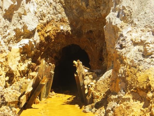
The Gold King Mine Spill released heavy metals to the Animas River. Photo courtesy of the EPA
The Gold King Mine spill occurred two years ago on Aug. 5, 2015 in Silverton, Colorado. The U.S. Environmental Protection Agency (EPA) was investigating the release of water from the mine and was hoping to remove material that had collapsed at the mine’s entrance. During removal, the loose material gave way, opening the mine tunnel and causing thousands of gallons of pressurized water to gush out of the tunnel and into Cement Creek, a tributary to the Animas River. This water had a low pH and was saturated with heavy metals which caused the Animas River to be slightly lower in pH as well. Luckily, the Animas watershed and abandoned mine lands had been studied extensively by U.S. Geological Survey (USGS) and Colorado Department of Natural Resources. This provides a baseline for water quality standards in the watershed and can help to determine if the water is safe for human consumption, domestic usage and/or agricultural use, but also to understand when downstream water bodies will recover.
Millions of people rely on water data, and on the water managers and public health officials who collect and analyze that data, for a safe and dependable water supply. When emergencies happen, like the Gold King Mine spill, citizens and water managers track water data to see what has changed, how much it has changed, and whether or not the water is safe—in such situations, up-to-date and accurate water data is crucial.
Data has played an important role in informing the cleanup of streams that have been affected by acid mine drainage from abandon mines. According to the Colorado Department of Natural Resources, there are over 23,000 abandoned mines in Colorado and over 1,800 miles of stream that have suffered the negative impacts of acid mine drainage.
Since August 2015, USGS and other researchers have collected water samples from numerous sites downstream of the Gold King spill site and along the Animas River. After the spill, scientists from many different organizations and agencies including the Mountain Studies Institute (MSI), the Southern Ute Water Quality Program (WQP), the EPA and USGS, tested water samples from the Animas River. Drinking water samples were taken every 30 minutes to track pH, dissolved oxygen, temperature and conductivity for two weeks. Drinking water samples were also taken every day for two weeks after the spill to determine whether the water was safe.
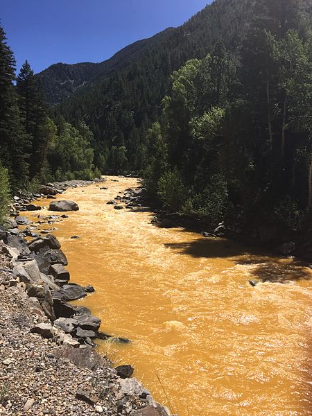
A slew of heavy metals from the spill turned the water a orange yellow color. Photo courtesy of Riverhugger.
From August 6, 2015 to August 11, 2015 MSI sampled the river. The tests on that water showed a slight increase in heavy metals but the levels did not exceed toxic water-quality levels. MSI estimates that a person would have to ingest two liters of water a day, four days per week for 16 weeks to experience any adverse health effects from the water. EPA Sediment samples taken on August 10th, August 12th, and August 13, 2015 from the Animas River showed that metal concentration levels were trending toward pre-event levels. This new data was then compared to the historic data from USGS and the Southern Ute Indian Reservation, where the tribe has been collecting water quality data since 1992 to create tribal water quality standards.
Today, the Animas River is healthy although, each spring, runoff from snowmelt turns the river a light shade of orange as the runoff stirs up old sediment. The WQP continues to take monthly water samples, semi-annual macro invertebrate samples, and annual fish tissue samples, while the state continues to monitor the fish population in the area.
USGS uses two different methods to collect data on the impacts of abandoned mine sites in Colorado and around the country—field studies and computer simulation models. Field studies collect water quality data to track the contaminants in the river and downstream of the release site, while computer models are used to quantify the transport of dissolved metals in streams. Data from both of these are then used in comparative analysis. In Cement Creek, scientists use the data to evaluate best management practices to meet and create standards for total maximum daily load. In Mineral Creek, scientists use the computer simulation models to accurately forecast post-cleanup water quality in the stream. Then, scientists compare pre-cleanup water quality data with post-cleanup water quality data to evaluate how accurate the model was.
Despite tests showing there was a minimal impact on the water quality of the Animas River, various parties such as the state of New Mexico and the state of Utah, are suing the EPA for damages to farms, tainted wells, and lost revenue from tourism. Among those parties is the Navajo Nation, suing for damages to crops and monitoring costs. According to the Denver Post, the president of Navajo Nation, Russell Begaye, has shown concern for his people and how they have been treated by the EPA, ”we need to hold the US EPA to their word according to their testimony. We are still waiting for reimbursement.” The Navajo Nation is looking for $162 million from EPA, including $3.1 million for reimbursement costs and $159 million for water development projects and monitoring. So far EPA has reimbursed the Navajo Nation almost $700,000 but claims that the river returned to its pre-spill state in September 2015, discrediting the lawsuit put forth by Navajo Nation.
 Print
Print
Reblogged this on Coyote Gulch.