Back in November, you may have seen the Buzzfeed post where Brits were asked to label the United States, with hilarious results. My favorite map (the second one) identified Colorado as “Squaresies.”
Looking at the outline of Squaresies, you might think that rivers didn’t play a big role in the development of the state. Unlike the many Eastern states that have at least one border defined by a river, Colorado’s boundaries are defined by degrees of latitude and longitude, established as Americans settled and carved up new Western territories.
But those straight borders belie the importance of rivers in shaping Colorado. Rivers have defined much of Colorado’s history. When American explorers first ventured into Colorado, they followed rivers. When Americans moved into the area, they settled near the rivers. Anyone who wanted to survive in Colorado had to live near a reliable water supply. But then Coloradans broke away from rivers. They began diverting the water to wherever they wished to settle. This has enabled people to live throughout the state, but Coloradans are still dependent on water, and new systems have created new challenges.
Watery Highways
Look at a map of Squaresies – no geographic features, just the shape. Now add Colorado’s major cities. Why did they develop where they did? The answer lies in water. Every major city in Colorado developed around a water source, as have cities across human history.
Rivers in cities today are not major features. Perhaps they are scenic spots, or navigational obstacles, or insurance hazards. But rivers were originally the sine qua non of towns and cities. Without them, people could not have congregated so densely. As Jared Orsi writes in the Citizen’s Guide to Colorado’s Water Heritage:
“Rivers meant food, shelter, energy, and, of course, water. They meant congregating, trading, and traveling. They were lifelines for the native peoples of the mountains and plains….Away from the rivers, the arid landscape offered potential starvation, dehydration, disorientation, discomfort, even death.”
So people built their towns around rivers. But early travelers also reached early towns by rivers. Colorado’s rivers themselves weren’t often used for transport, but rivers were nevertheless the interstate highways of the day, as they offered a path to follow through then-unknown territory. And much like interstate highways today, sustenance could be found nearby. Straying too far from rivers could lead early travelers to disaster.
In the early 1800s, American explorers followed rivers into Colorado. Some of the earliest explorers came specifically to map rivers and discover their places of origin, since rivers were often used as boundaries between territories – in this case, between the United States and the Spanish colonies. But these explorers were not impressed with the harsh environment of the West. One explorer, Stephen Long, famously dubbed the region between the Mississippi River and the Rocky Mountains as the “Great American Desert.” This “desert” did not sound like an appealing place for Americans to settle. Indeed, many Americans skipped the region entirely as they headed west, aiming instead for the more distant lands of California and Oregon (and of course, they followed rivers to reach both).
Bringing Water Where It’s Wanted
But by the 1870s and 1880s, Americans were ready to take a crack at settling the Great Plains. Many used railroads, the new superhighways, to reach Colorado, rather than following rivers. But once they settled, they still depended on water. Colorado’s semi-arid climate and far-flung streams posed a challenge for farmers, but human ingenuity soon provided an answer. If water does not arrive at the location or time or in the quantity desired, human-engineered reservoirs, ditches, and pipelines could fix the problem.
Coloradans accordingly adopted a system of water law based not upon proximity to the water source (the Eastern tradition, known as riparian law), but instead upon the first to claim the water for beneficial use (known as prior appropriation).
But Colorado’s rivers still posed a challenge to settlement. The state straddles the Continental Divide, and about 80% of Colorado’s water falls on the Western side. But the majority of Colorado’s population settled and grew on the Eastern side. Under prior appropriation, the user of water does not need to live near the source. Diverting extra water from the Western side of the Divide seemed an ideal solution for the thirsty Eastern side. But residents of the Western Slope began to worry that their own development was being compromised for the needs of the Eastern Slope. (Read more about those transbasin diversions and the history of their negotiation next month in the new Citizen’s Guide to Colorado’s Transbasin Diversions.)
Furthermore, many other Western states had adopted prior appropriation water laws. These states depend upon rivers that originate in Colorado, and Coloradans soon worried that these other states – especially California – would out-claim and out-develop Colorado. This led to the adoption of interstate compacts between the states over their shared rivers.
Boundaries Based on Basins?
Clearly, water continues to shape the development of Colorado, despite the boundaries that are not defined by rivers. As Colorado’s population continues to grow, Coloradans must decide how best to manage and divide its water resources.
Some have even questioned the wisdom of Western state boundaries. Do Colorado’s seemingly arbitrary boundaries encompass people and environments that have enough in common to make decisions for the good of all? Perhaps Colorado should be divided into East Slope and West Slope states. Or perhaps all the Western states should be divided according to their watersheds: explorer John Wesley Powell proposed such boundaries in 1879.
State lines based on watersheds might encourage us to make better water decisions, as Powell proposed. But do cultural similarities follow river lines, any more than rain follows the plow? Or would watershed states have faced the same problems that Squaresies, with its diverse populations, faces today?

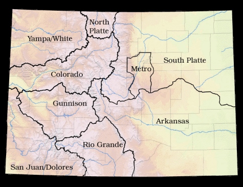
Colorado’s river basins and Basin Roundtables
Colorado’s Water Future
So Coloradans are unified by square boundaries, and further divided and united by river basins. Each basin has its own unique challenges. Today, nine Basin Roundtables meet to discuss the needs of each basin, and currently, each basin is developing its own Basin Implementation Plan. These plans will identify each basin’s specific challenges to a secure water future, strategies to address these challenges, and projects and methods that the basin may implement to meet its water needs. These Basin Implementation Plans will be incorporated into Colorado’s Water Plan, which aims to outline a secure water future for the entire state.
Perhaps it would be easier to make water decisions based on watersheds, rather than state boundaries. Coloradans have a square (water) bed, but there’s no reason to just lie in it. We can still seek a secure water future for all.
 Print
Print
What’s Happening i’m new to this, I stumbled upon this I’ve
found It positively useful and it has aided me out
loads. I’m hoping to give a contribution & help other users
like its aided me. Great job.