Colorado’s worst-ever wildfire season in 2020 prompted communities to develop new strategies for shoring up water resources. Here’s what they learned.
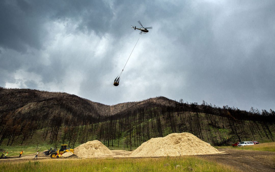
In June 2021, helicopters buzzed across the skies above Altona, Colo. Their mission wasn’t to battle wildfire. That quest had been achieved in November 2020, when firefighters declared 100% containment of the 10,106-acre CalWood Fire, the largest ever recorded in Boulder County. Instead, helicopters were working to protect the region’s water supplies from the sediment runoff that commonly follows high-severity wildfires like the CalWood blaze. With summer thunderstorms imminent, there was no time to lose.
Teams of sawyers felled trees and tethered them to helicopters, which flew their cargo to a separate staging area where the wood was mulched and scooped by the half-ton into huge nets. More helicopters carried mulch loads back to the scorched CalWood hillsides to be spread atop ash and soil to hold it in place. Every rainless day was a boon to the effort to mitigate impacts from the previous fire season, buying valuable time for the teams at CalWood and other Colorado locations affected by 2020’s record-setting wildfires to prepare and stabilize soils before the late-summer monsoons hit.
Throughout 2020, more than 6,700 separate wildfires burned a total of 744,120 acres across Colorado, according to the Rocky Mountain Area and Coordination Center 2020 Annual Report. Many of the summer and fall fires were high-severity burns that created hydrophobic soils that prevent precipitation from being absorbed into the ground, explains Jessie Olson, executive director of Left Hand Watershed Center. Rain falling on the impermeable soil releases torrents of ash and sediment into streams and rivers, choking them with debris. And with fewer living plants left to slow the water’s path or anchor the soil in place, flood and mudslide risks rise.
“Catastrophic burns have dramatic impacts to soil stability that overwhelm the balance in unnatural ways,” Olson says. In late June 2021, when the first summer showers hit the CalWood burn scars, Left Hand and St. Vrain creeks ran black with suspended sediment.
Such particulates increase minerals, nutrients and heavy metals in the water, while decreasing the available oxygen, causing fish kills and leading to more frequent and intense algae blooms. Sediment also clogs the spaces between rock cobbles in riverbeds where bugs and fish lay eggs.
Debris and the flood waters that carry it also pose problems for water managers. For example, debris events blackened the Cache La Poudre River this summer after rains hit the burn scar from 2020’s Cameron Peak Fire. Greeley had to close intakes from the Cache La Poudre River at the beginning of July 2021 to avoid burdening its treatment plant with processing the blackwater’s ash and debris. Instead, it relied more heavily than usual on water from the Colorado-Big Thompson Project’s Horsetooth Reservoir, and will continue to do so when the river is too turbid to treat, thanks to an agreement it negotiated with an irrigation company where irrigators are using Greeley’s Poudre River water while allowing Greeley to use an equal amount of their Colorado-Big Thompson Project water.
Indeed, impacts to water resources from 2020’s fire season “are just starting to happen now,” says Chris Sturm, watershed program director for the Colorado Water Conservation Board (CWCB). “As great a threat as the fire was itself, the greatest threat is probably still to come, from flooding.” Actions taken in response to fire are most critical during the immediate year post-fire, since that’s when flooding and debris can be most detrimental—but the threats to watersheds typically continue for three to five years, sometimes even longer depending on geology and other factors. High-severity burns on extremely steep slopes can require a decade or more to stabilize. “As evidenced by summer debris flows in Glenwood Canyon, Poudre Canyon, and off the East Troublesome burn area, post-fire flood and debris flow hazards continue to be a great threat for months or years after a wildfire,” Sturm says.
Altona’s helicopter brigade was just the beginning.
Post-fire recovery and emergency response
There’s no “one-size-fits-all” approach to mitigating post-wildfire flooding and water contamination. “Every community must develop its own array of operations, based primarily on the affected terrain,” says Sturm. “However, there are standard technical approaches that should be employed to inform response actions.” He references approaches including stakeholder collaboration, engineering and modeling, and preparation of design concepts.
Greeley, for example, experienced wildfire across the collection areas for four of its mountain reservoirs. Instead of filling those reservoirs as is typical in spring, the municipality decided to leave them empty—allowing the streams to flow through rather than be collected behind the dams—to prevent sediment from filling in the basins.
As with many other wildfire-scarred regions across the state, Greeley has also been working to secure burned soil to the hillslopes to reduce runoff and slow sediment flows, either by staking straw wattles to the hillsides or by mulching. Mulching works on slopes that range in steepness between 20% up to a 65% grade, according to a 2021 Ecological Restoration Institute paper on mitigating post-fire runoff. Steeper than that, and mulch won’t cling to the hillside, while on flatter ground, there’s little risk of erosion. “Mulching can be very effective, in that it actually holds moisture and keeps the earth in place,” says Sturm. But mulching is expensive, costing $2,100 to $4,000 per acre. Other approaches include closing burned areas to allow for natural recovery, reseeding, removing debris, closing roads and armoring drainage ditches, among many others.

When 2021’s summer rains hit the steep slopes that burned in 2020’s Grizzly Creek Fire above Glenwood Springs, Colo., destructive mudslides caused Interstate 70 to shut down. Courtesy Glenwood Springs Fire Department
On extremely steep slopes, such as the ones that burned last year in the 32,631-acre Grizzly Creek Fire above the City of Glenwood Springs, Colorado, hillslope mitigations aren’t viable. Instead of working to slow sediment-laden water coming from No Name Creek and Grizzly Creek, its primary water sources, that city prepared to process it. Glenwood Springs upgraded the filtration technology in its water treatment plant so that it can now handle extreme levels of turbidity, though at a reduced processing speed. It also improved the piping infrastructure for its secondary water source on the Roaring Fork River. And to guard against the damaging effects of mudslides, Glenwood Springs reinforced the structure of its water intake on No Name.
Proving just how vulnerable slopes in the area are post-fire, major mudslides, debris flows and flash flooding triggered by summer rains over the Grizzly Creek Fire scar closed Interstate 70 on 31 days between July 1 and Oct. 20. More than half of those closures lasted all day. As of press time, CDOT crews had hauled away 4,335 truckloads of debris, totaling up to 56,355 tons of mud, trees and rock. In response Gov. Jared Polis issued two disaster declarations: one authorized the Colorado National Guard to help with traffic control and debris management while providing funds to respond to the damage. The other enabled Colorado to seek federal funds to help with highway repair.
Sometimes, consequences from severe fires simply can’t be fixed or mitigated—that’s when warning systems come into play. Glenwood Springs is partnering with the U.S.Geological Survey (USGS), the Colorado Department of Transportation, and the nonprofit Middle Colorado Watershed Council to install eight rain gauges that can alert downstream communities like De Beque, which sits downstream of Glenwood on the Colorado River, to storm events that could necessitate shutdowns or evacuations.
“Having enhanced information from the rain gauges will let us make decisions about major tourist areas like Hanging Lake, so we can evacuate and protect people who are recreating there without crying wolf [with unnecessary shutdowns] every day,” explains Paula Stepp, executive director for the Middle Colorado Watershed Council. The rain gauges and related warning system will also forecast the need for shutdown to municipalities along the Colorado River corridor, so they can respond to debris events before they accrue costly damage. Larimer County also developed a “reverse 9-1-1” emergency alert system to help warn residents of flash flooding.
Quickly Building Partnerships
In the wake of 2020’s East Troublesome Fire, the second-largest recorded in state history, stakeholders worked together on a speedy and inventive response. That blaze charred 193,812 acres across Grand and Larimer counties, on primarily public land—68% of the burn affected U.S. Forest Service holdings, while 10% was on private property. That public/private ratio presented a problem for water resource protection because by November 2020, when this late-season fire was winding down, the already cash-strapped USFS had depleted its annual budget for wildfire response. And the Natural Resources Conservation Service (NRCS), which provides post-wildfire mitigation funds via its Emergency Watershed Protection program, primarily releases money for work on private land.
Still, private lands amounted to a whopping 19,000 acres—enough to have a meaningful impact on the water supplies for Northern Water, the transmountain diverter and water provider that serves more than a million residents across eight counties in northeastern Colorado. Northern stepped forward to serve as the local administrator for NRCS funding that could be used for mitigation projects on private property in strategic locations, such as immediately upstream of water supply infrastructure. C Lazy U Ranch, for example, manages a two-mile section of Willow Creek just upstream of Northern Water’s Willow Creek Reservoir. After the fire, the ranch built sediment ponds that collect debris before it’s flushed into Northern Water’s reservoirs.
“There weren’t many entities in the region that had the capacity to sponsor a program of this size,” explains Esther Vincent, Northern Water’s director of environmental services. “It requires managing contracts, working with scores of landowners, tracking expenses, and generating 25% of the funds as a cost-share, which amounts to millions of dollars,” she explains. “It became very clear that, if we were going to do this, we needed to do it in partnership with others in the area.”

At the East Troublesome Fire burn area near Grand Lake, Colo., Sen. Michael Bennet hears from staff with the Middle Park Conservation District, Natural Resources Conservation Service, Grand County and Northern Water in May 2021.
Courtesy Northern Water
Fortunately, in recent years, Northern Water had already strengthened its relationship with Grand County, the Middle Park Water Conservation District, the Three Lakes Watershed Association, and other regional stakeholders. “But the wildfire response took that to a whole new level,” Vincent says. “We never would’ve been able to do what we did without those pre-existing relationships.”
The allegiance gave rise to “the fastest MOU drafting that I’ve ever been through,” claims Vincent, who forged a voluntary memorandum of understanding that established both Northern Water and Grand County as co-sponsors for NRCS project funding. The sponsors subsequently tackled the sometimes overwhelming task of coordinating the many local entities that needed mitigation or offered data: About 150 people and some 40 agencies were involved in the email chains and weekly check-ins that merged the technical assessments to identify the areas of greatest mitigation concern. The USGS, the USFS, the CWCB—these and other entities were conducting their own burn damage surveys and reports, all using disparate platforms and requiring GIS analysis. Each of those studies helped land and water managers understand what was at risk and most vulnerable to the fire’s aftereffects, including water and infrastructure resources: which buildings should be protected with mulching, or which waterways were most susceptible to debris events. Assessments, triage, and restoration efforts all had to be executed between late October, when the fire blazed, and May or June, when rains would wash ash and soil off the scars and trigger flooding. Moving quickly was critical.
The newly formed partnership scrambled to develop tools for merging various data sources. They consulted existing resources, such as the one invented by the Coalition for the Poudre River Watershed, which created collaborative systems following the 2012 High Park Fire. But nothing met the specific needs of the East Troublesome group, which ended up engineering its own tools using Northern Water’s team of GIS experts.
The takeaway, says Vincent, is that for communities to be ready to recoup after wildfire, they need to be skilled with collaborative platforms, such as SharePoint, and they need to have GIS expertise—if not in-house, then readily available via contract. Such readiness will help communities conduct their assessments with speedy efficiency, so they can quickly pivot to mitigation work.
What would be even better, says Vincent, would be for the state to develop such tools and capability, to which individual communities could have access. That’s exactly what’s happening, for all communities to use in similar times of need. To help with resource sharing, CWCB’s Technical Assistance Team was formed in fall 2020 to assist communities with watershed protection work in the wake of wildfire.
“We realized that it was a lot more beneficial to send technical resources right out of the gate, rather than send money to start the process of hiring engineers,” Sturm explains. Not only does the Technical Assistance Team help communities respond to threats more quickly, but it also keeps them from reinventing solutions to problems that other regions have already faced and solved. Thus the team’s assessments of post-burn hydrology and hydraulics, modeling of sediment and debris flow, and advice on permits and funding represent the best practices from wildfire-affected communities across the state.
The first year is the most critical for addressing flooding, says Sturm, though mulching and other mitigation measures continue to be effective in the second or third year after fire—when strategies may evolve to promote tree regrowth and address any erosive stream channels that may be forming on hillslopes. Thus the Technical Assistance Team can help steer communities well beyond the first year or crisis.
More state support is coming, thanks to June 2021 legislation that offers $30 million to the CWCB for wildfire mitigation, emergency response, and watershed restoration. $500,000 of that funding will create what CWCB calls “Wildfire Ready Watersheds.” Through the program, CWCB will analyze statewide wildfire risk and susceptibility and develop a framework that communities can use to plan for wildfire preparedness and to address post-fire hazards.
Paying for mitigation
Funding is the crux when it comes to preparedness, mitigation and fire recovery. “This is a huge effort, and it’s really expensive,” says Jennifer Petrzelka, Greeley’s water resources operations manager. In her four-person office, half of the staff’s time and energy goes to finding funding for mitigations that shore up water resources post-wildfire. The rest goes to executing those projects and continuing the municipality’s day-to-day operations.
The strain on Greeley’s staff is due, in part, to USFS funding shortages. The USFS has historically operated its own mitigation program, called the Burned Area Emergency Response (BAER), which assesses wildfire damage and implements restoration efforts to mitigate impacts on waterways within federal lands and beyond. But BAER, like the agency overall, is crippled by a lack of money, leaving few avenues for emergency mitigation on national forests. Greeley achieved a work-around by getting federal permission to use the NRCS’ Emergency Watershed Protection program funding on public land, and Petrzelka would like to see such special-use permits approved more permanently, for uses beyond the Cameron Peak Fire.
Limited capacity within the USFS also hindered responses to the East Troublesome Fire, where the Arapaho National Forest identified $127 million in projects requiring post-wildfire recovery, and estimates for all costs, including those on private properties, exceed $170 million. Yet only $57 million has been received thus far, and more than 60% of that funding is dedicated to restoration on non-federal lands that qualify for NRCS dollars. Thus, most of the funding gap—which exceeds $120 million—affects mitigation that’s yet to be completed on USFS land. may provide some money for wildfire restoration on those parcels, but it’s not clear how much is specifically earmarked for fire recovery.
In the future, all will benefit from CWCB’s recently funded Wildfire Ready Watersheds program. “It wouldn’t have happened if we hadn’t worked together and testified together and petitioned delegates from both sides of the [Continental] Divide,” says Vincent, referring to the way that representatives from the East Troublesome and Cameron Peak fires joined forces to secure funding.
Such allegiances are best formed before crisis hits, sources agree. To be proactive, communities can start strengthening their relationships across stakeholder groups now, before the next wildfire burns. Because if 2020 taught us anything, says Sturm, “It’s that there are going to be wildfires. People are no longer wondering if this will happen, but where and when.”
Correction: An earlier version of this story misstated the name of the Middle Park Water Conservation District
A freelance writer living in Steamboat Springs, Kelly Bastone covers conservation and the outdoors for publications including Outside, AFAR, 5280, Backpacker, Field & Stream, and others.
 Print
Print