Colorado’s Climate
Colorado’s warming potential by 2050, as projected by statewide climate models
With warming, Colorado’s snowline is also expected to shift, raising the lowest elevation at which snow falls. In other words, lower elevations could see more moisture falling as rain rather than snow and an increasing risk of floods from rain-on-snow events. This change would also reduce the amount of water stored in snowpack throughout the winter.
Variable Precipitation
While 17 inches is the statewide annual average, the arid San Luis Valley in south-central Colorado sees around 7 inches of precipitation each year while some mountain areas get a whopping 60 inches, according to the National Oceanic and Atmospheric Administration.
High-elevation snowpack (up to 600 inches in some areas) is Colorado’s natural form of water storage. Heavier, water-vapor-loaded spring storms originating in the Pacific Ocean rise over the mountains and condense, creating precipitation mostly on westward-facing slopes.
Then from April through September, precipitation occurs over the eastern portions of the state as warm, moist air from the south is carried northward and westward into Colorado’s higher elevations. Likewise, moist air from the southwest finds its way to southern and western Colorado through a “monsoon” season from July through September. Then the cycle repeats.
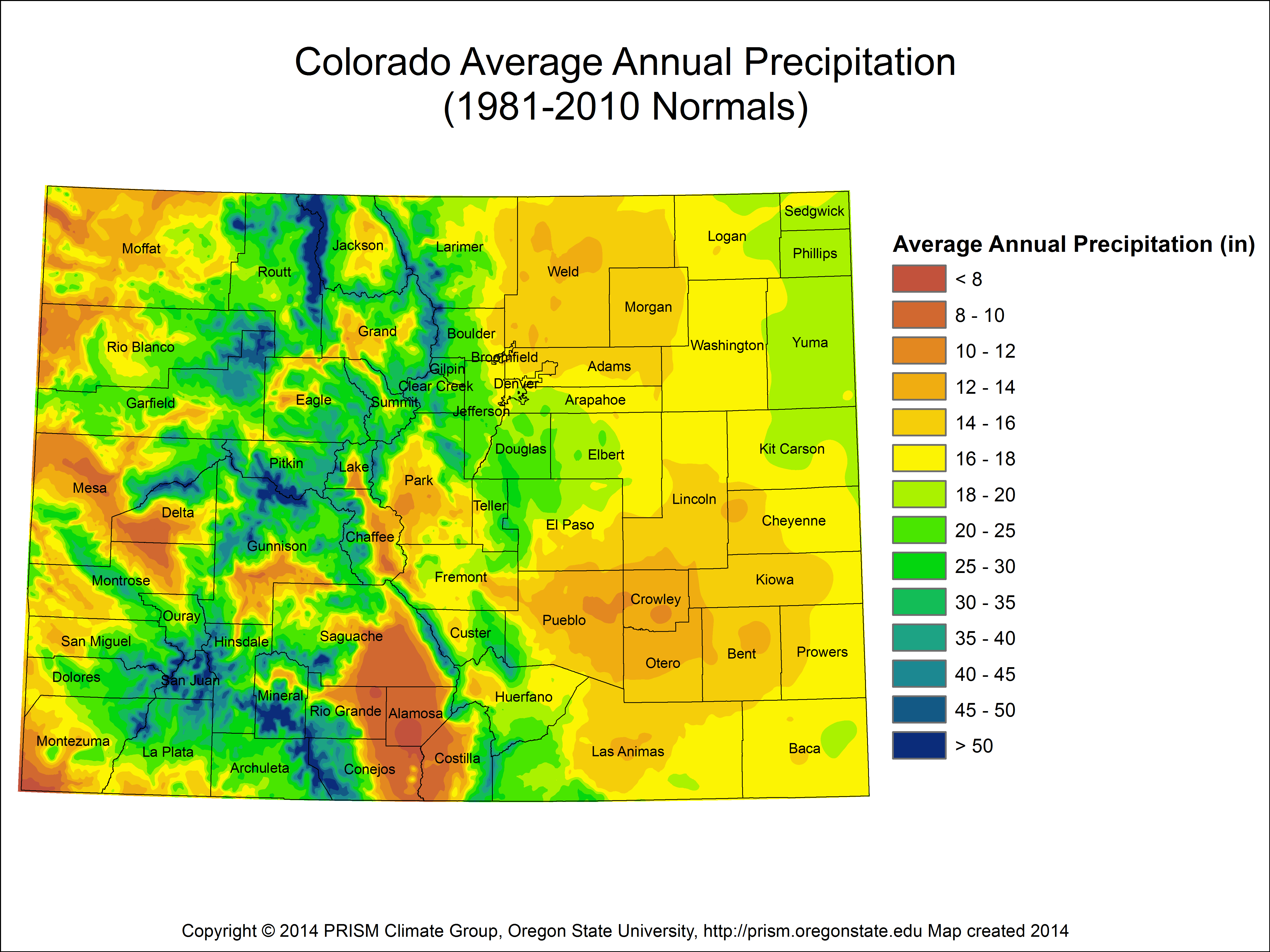
The average annual precipitation in Colorado varies with the state’s topography, with some regions receiving less than 8 inches of precipitation and others receiving more than 50 inchea each year. This map is based on data from 1981-2010.
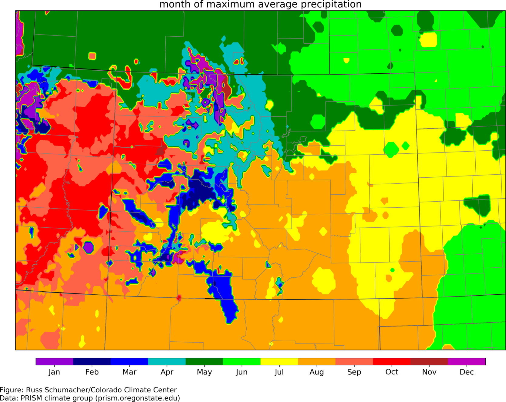
The month of maximum precipitation varies across the state. Colorado’s geography is so diverse that every month brings peak precipitation somewhere. Spring storms dominate over the northern Front Range and northeastern Colorado, winter precipitation dominates over the high elevations, and late-summer monsoons bring moisture to southern Colorado. This map was produced by the Colorado Climate Center and is based on data from 1981-2010.
Temperature
Colorado’s notoriously high elevation also affects temperatures, which decrease with an increase in altitude. On Colorado’s Eastern Plains, for example, summer temperatures can settle in at 95 degrees or above. But on Colorado’s highest peaks, summer highs are much lower—between 50 and 70 degrees. In fact, nighttime temperatures on mountains up to 14,000 feet above sea level can dip below freezing, even at the height of summer.
So how does Colorado’s climate and temperature affect water supply? Higher temperatures during the summer months can result in increased evaporation rates and a greater water demand from forests and other native vegetation. Likewise, higher temperatures during the winter and spring months, one effect of climate change, can translate to less snowmelt—with snow sublimating, or evaporating directly into vapor during the winter—and earlier runoff.
Drought
During years with low precipitation, drought can result in water shortages that affect reservoir storage as well as soil moisture and streamflows. According to the Colorado Water Conservation Board, it is rare for the entire state to experience drought at the same time. However single-season droughts affecting some portion of Colorado at any given time are common.
In a short-term drought, a combination of low precipitation and high temperatures, which exacerbate drought symptoms through increased transpiration rates for plants, leads to a soil moisture deficiency. As droughts deepen and become longer term, plants become stressed, streamflows recede, and reservoir levels shrink.
This can cause far-reaching impacts to Colorado’s economy and its environment, including agriculture, recreation, tourism, fish and wildlife. Extreme drought conditions can result in emergency and disastrous conditions, including loss of crops, low streamflows, increased stream temperatures that result in fish kills, and an increased threat of wildfire.
2002 & 2020
Colorado’s two driest years on record. Scientists and water managers believe these are the result of a multi-decadal drought period, signaling what may be a transformation of Colorado’s modern climate through a process called aridification
Floods
Because of Colorado’s unique climate and topography, storms can lead to another extreme: flooding. “To get rain-induced flooding, you need a weather pattern that brings in a lot of water, and then you need to lift it,” says Jeff Lukas, a climate researcher and consultant.
There are three types of lifting: frontal, when two air masses collide forcing warmer air up and over cooler air; convective, when low-level air warms up and rises, resulting in severe thunderstorms; and terrain, when up to 6,000-foot elevation differences create lift and cooling and can bring precipitation out of moist flow.
This dynamic, in combination with frontal lifting, bore out during historic flooding on Colorado’s heavily populated Eastern Slope in 2013. While the 2013 fall flood was extreme, it wasn’t unprecedented. In fact, says Kevin Houck, chief of watershed and flood protection for the Colorado Water Conservation Board, “In a state like Colorado, there’s so much variation we likely experience a 100-year flood somewhere every year, although most are not in populated areas.”
$85 million


