Water management adapts to include recreation
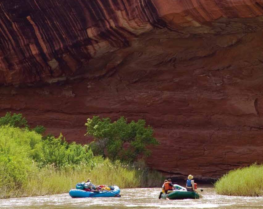
As the story goes, a group of private boaters had put in for a two- to three-day trip down the Dolores River in southwestern Colorado. Forecasts for releases from the McPhee Dam upstream were favorable, and the group had everything timed and loaded. But the water didn’t last, and the group found themselves stranded down a river, without a river. Whether a true tale or urban legend, the prevalence of this campfire story has dogged boaters on the Dolores River for years.
On a river considered by American Whitewater to be an icon of the West, second only to the Grand Canyon as a uniquely southwestern, multi-day float with high-quality rapids, unpredictable flow management has led to a steadily declining boating industry. Although some of that decline can be attributed to the “dry 2000s,” whitewater recreation on the Dolores has effectively shrunk by 75 percent from what it was during the “wet 1990s.”
“People come from all over the world to float the Dolores,” said Nathan Fey, director of American Whitewater’s Colorado Stewardship Program. “If they could better predict flows it would have far-reaching benefits to the area.” The Colorado River Outfitters Association reported that in 2008, with 868 commercial users on the Dolores, direct expenditures in local communities were nearly $100,000, with a total economic impact of $246,000.
Statewide, water-based recreation-including boating, fishing and skiing, to the extent it has become a form of water-based recreation due to the growing importance of snowmaking-is a multi-billion dollar industry. But despite its strong presence today in Colorado’s economy, water-based recreation is struggling for access in places where most of the water has long been appropriated for more traditional agricultural, municipal and industrial uses. Such uses are fundamentally at odds with recreation because they take water out of the rivers to use it while water-based recreation, with the exception of snowmaking for skiing, depends on water being in the rivers and reservoirs.
Water managers at all levels, from local towns and conservancies to the largest federal projects, are still in the throes of working out the complex challenges stemming from recreation’s new demands.
Down on the Dolores
The primary purpose of the Dolores Project, consisting of McPhee Dam and Reservoir on the Dolores River, is to provide a dependable water supply for irrigable lands outside the Dolores Basin, in the Montezuma Valley of the San Juan Basin, where irrigators hold pre-1900 rights on most of the river’s water. It also has some municipal users and delivers to the Ute Mountain Ute Indian Reservation.
But since the Dolores Project first began delivering water in 1986, much has changed in the management picture. Additional obligations for the project were laid on one by one. The original Environmental Impact Statement acknowledged that building McPhee would impact recreational boating downstream, and stipulated that the Bureau of Reclamation should operate the reservoir to maximize rafting days. Now whitewater boaters in the canyons below the dam are lobbying for more predictable releases of excess “spill” water they feel should be timed such that they can take advantage.
Fishermen, meanwhile, desiring a healthy sport fishery downstream of the dam-one of the project’s authorized purposes-are concerned as the reservoir’s designated “fish pool,” set aside specifically for ongoing releases to benefit trout, has fallen below the targeted volume. In addition, the Bureau of Land Management is revisiting previously identified “outstandingly remarkable values” that qualify the Dolores for Wild and Scenic River designation, which implies proscriptive federal involvement in river management. And three “sensitive” native fish species in the lower Dolores could also draw a larger federal presence if they become “endangered.”
All of these competing pressures come home on the Dolores Water Conservancy District, which is contracted by Reclamation to manage McPhee Dam. The district essentially operates McPhee according to a “fill and spill” policy: fill the reservoir and only then, if there’s additional inflow, let excess water go downstream. Flows below the dam for most of the year-or all year during dry years-are insufficient for boating. The district says rafters need at least 800 cubic feet per second on the Dolores. This year, there were 11 such days, and only four at the rafters’ preferred level of 1,000 cfs or more.
During wet years, when forecasted runoff is high, the operational procedure shifts to “spill and fill” in an effort to avoid overfilling the reservoir and creating a host of other problems. District manager Mike Preston, whose first year on the job was 2008, a wet “spill and fill” year, says he was initially popular with boaters. “We released 185,000 acre feet over 85 days,” he said. The past two years have been drier, with only 30,000 acre feet spilled in 2010. While the district wants to please boaters, Preston says it will always err on the side of filling the reservoir for its municipal and agricultural users.
The district is, however, confronting the reality that it has more users to serve than its traditional ones. Reclamation formed a spill committee that includes recreational stakeholders to assess snowmelt projections and the likelihood of filling the reservoir as well as how to handle any excess water. Still, such planning doesn’t guarantee a positive outcome for boaters. In late May and early June of this year, just a few weeks after the committee determined McPhee wouldn’t have any extra water, the district spilled above 800 cfs, enough for kayakers and rafters, for seven days with several more 1,000-plus days coming a few days later. The problem, says Fey, is that only locals paying close attention can take advantage of such last-minute, unannounced releases.
Fey views the committee as a potential opportunity, however, to examine whether collecting additional data could make projections more accurate and allow Reclamation to take more risk in scheduling releases. Preston says he is all for having the best data possible, but that some variables will always defy predictability, especially temperature. He says the line between “fill and spill” and “spill and fill,” however, could be tweaked.
The district has facilitated the participation of other concerned citizens through a different venue. Former, longtime district manager John Porter summarized the motivation for doing so in a sentence: “If anyone says they are a stakeholder, then they are, and you’d better listen to them and figure out how to talk with them.”
Porter followed his own advice when Chuck Wanner of the San Juan Citizens Alliance’s Dolores River Coalition approached him in 2002 about environmental and recreational issues on the lower Dolores. Together they set up what has become the Dolores River Dialogue, a gathering of stakeholders working to “improve the ecological conditions downstream of McPhee Reservoir while honoring water rights, protecting agricultural and municipal water supplies, and the continued enjoyment of rafting and fishing.”
Assessing the flow requirements for native fish species and how they differ from those of the tailwater fishery is taking up much of the Dialogue’s time right now, according to Preston. The Dialogue also spawned a Lower Dolores Working Group, which itself has around 50 stakeholders collaborating to help the BLM develop a Resource Management Plan for the lower Dolores that could stave off Wild and Scenic designation.
Porter’s daughter, Marsha Porter-Norton of Durango, is now facilitating the Dialogue and she is optimistic, pointing to a “framework” process they are using to move beyond stakeholder wish lists and develop “do-able alternatives.” She sees a focus on “what we can do together that we can’t do separately.”
Compromise over flows
Stakeholders on the Dolores might look for hope at a similar process that has been used successfully since the late 1970s on the Taylor River, a tributary of the Upper Gunnison River.
The Taylor has the classic Colorado mountain river profile: mountain streams converging in a high-altitude park, then dropping into 20-some miles of beautiful canyon-with a 200-foot dam at its head, backing up a 100,000 acre-foot reservoir. Taylor Park Dam was built in the 1930s to store irrigation water for the Uncompahgre Valley 100 miles to the west. From then until 1975, the Taylor was functionally an on-and-off canal rather than a river, carrying reservoir releases on demand to the Uncompahgre irrigators.
But in the 1960s and ë70s, Reclamation built the three Aspinall Unit power and storage dams in the Gunnison River canyons lower down, and a 1975 exchange agreement permitted storage of the Uncompahgre water in the new Blue Mesa Reservoir. Since that water could be moved between the two reservoirs independently of irrigator demands, the Taylor could run like a “real” river again.
But a real river by whose standards? Upper Gunnison Basin irrigators want water held back for late summer use; a healthy flatwater recreation economy on the Taylor Park Reservoir behind the dam wants high reservoir levels; a growing whitewater rafting industry below the dam wants good reservoir releases through the summer; and a slew of fishermen along with landowners who own substantial stretches of riverside property want a sport fishery re-established with appropriate “fish flows,” as recommended by the Division of Wildlife.
These often conflicting desires are resolved through a “Local Users Group.” Every spring, armed with Reclamation’s April estimate for the year’s runoff, representatives from the user groups map out a flow regime for the summer and fall. This has evolved, over a couple of decades, into a generally amiable meeting in which all parties know that they will get enough of what they need to operate, and that there will be no big winners or losers. The group’s recommendation is usually adopted without major changes in normal-flow years by Reclamation and other invested agencies. Through this process, the Taylor is a “river once more,” albeit a thoroughly managed river.
Water for snow
In the case of snowmaking, where water is withdrawn from the stream to serve recreational demand, management issues look slightly different. Today, snowmaking has gone from a “backup” operation to a “necessity” in a recreational industry that is pushing the limits of natural snowfall. But snowmaking withdrawals come at a time when mountain streams are at their lowest and most vulnerable stage, causing instream flow management challenges for the protection of winter-stressed fisheries.
Since 1973, the Colorado Water Conservation Board has been authorized to hold instream flow rights to keep a certain amount of water flowing through rivers for environmental benefits. In the Blue River valley above Dillon Reservoir, Keystone and Arapahoe Basin withdraw water for snowmaking from the Snake River. According to Blue River water commissioner Scott Hummer, the resorts try hard to stop short of drawing the Snake down below its state-established minimum winter instream flow of 6 cubic feet per second, but they are also maximizing their withdrawal. “The slightest variation in temperature regime or weather pattern can set off the bell in the Colorado Water Conservation Board office in Denver,” said Hummer. By the time the snow guns are shut down, the fishery may already be damaged. The resorts have stipulations with the Division of Wildlife that require them to do some spring trout stocking when that happens.
In their search for snowmaking water, the resorts get creative. Keystone practices a strange diversion from a diversion, pulling water from a shaft on Denver Water’s Roberts Tunnel, where water leaves Dillon Reservoir en route to Denver. When Denver Water announced it would drain Roberts Tunnel for needed repairs this fall, Keystone and Summit County worked out an agreement that involves paying Denver Water $120,000 to delay maintenance on the tunnel and allow snowmaking to continue until mid-December when, weather willing, the resort will be getting natural snow.
Vail Resorts has also entered into a creative agreement with a water supplier, the Eagle River Water and Sanitation District, along with Ski and Snowboard Club Vail. Together, the three organizations installed a $2.6 million snowmaking system to use snowmaking water owned by Vail as well as treated water going stale in the district tanks under low fall demand. They make enough snow on Golden Peak for Ski and Snowboard Club Vail to begin training competitive skiers and snowboarders, including local kids and Olympic medalists like Lindsey Vonn, 45 days prior to the opening of the main resort.
Protecting water quality
Municipal water managers face another kind of recreational challenge: protecting water quality in watersheds that are also their customers’ playgrounds. The city of Boulder practices the extreme solution of simply fencing off much of its municipal supply watershed, thereby avoiding many of the problems associated with the juxtaposition of municipal watersheds and public lands managed for “multiple use.” The areas closest to town tend to be the most heavily traveled, and the rising popularity of off-highway vehicle use has contributed to sedimentation and erosion problems for municipal reservoirs.
The city of Grand Junction and the Forest Service have collaborated successfully on Grand Mesa, virtually all of which is a year-round recreational mecca as well as a source of municipal and irrigation water for the surrounding valleys. The two entities have cooperatively managed the municipal watershed in some form since 1906, when the city actually helped fund the local ranger. Since then, the partnership has fostered many innovative activities to promote watershed health and reduce the likelihood of catastrophic fire damage, to the extent that Grand Junction was awarded the Regional Forester’s 2009 “Water Partner of the Year” award.
Forest Service realty specialist Linda Bledsoe describes a number of “agreements that kind of evolved” in her work in the Grand Valley District. Grand Junction contributed $336,000 in 2008 for vegetation treatments on Forest Service land within the city’s watershed and will have invested another $300,000 in that pursuit by 2013. Most of these funds go toward trail maintenance to reduce erosion and keep sediment out of the streams and many small reservoirs that dot the mesa. Bledsoe helped persuade the Thunder Mountain Wheelers, an OHV club, to contribute money and labor to dealing with some of their own impacts on the mesa; a day with a shovel building water bars and other trail repairs makes people more aware of their environmental impacts.
“Every Forest Service line officer dreams of this sort of support and partnership,” said Bledsoe’s supervisor, Grand Valley District Ranger Connie Clementson, whose opinion is strongly echoed by Bledsoe.
And so the flux continues, with traditional water managers increasingly willing to assemble the stakeholders to do the hard work of coming up with those “do-able” alternatives-not as an evasion of responsibility, but as the only reasonable way to address the multitude of conflicting requests now battering every management decision. Even something as seemingly innocuous as incorporating flatwater recreation on an existing reservoir, for example, is more complicated than it looks, as local pressure to keep reservoir levels high comes during the same season when traditional users need to draw them down.
The “tectonic shift” underlying all of this was summarized a few years ago by Colorado Supreme Court Justice Greg Hobbs: “We are no longer developing the resource; we are learning how to share the developed resource.” That is, practically by definition, a matter of give and take by all parties-within a system of prior appropriation, true, but it has often been noted that a legal system too inflexible to cover changing circumstances will eventually break under their pressure.
 Print
Print