Packing out the Instream Flow Program in Rocky Mountain National Park
It’s easy to miss the turn into the Wild Basin entrance of Rocky Mountain National Park. This out-of-the-way, dirt-road entrance sits just below the highest mountains in the park on its southeastern side near Allenspark. Cross through the gate and you’ve entered lands reserved by the federal government under the National Park system. Cross a creek 3 miles down the trail to Sandbeach Lake and ask: Does that creek have minimum flow protections? We know the land is protected, but is the water? A backpacking trip in the park provides a glimpse into Colorado’s Instream Flow Program.
Go:
The Sandbeach Lake Trailhead begins right at the gate of the Wild Basin Entrance, a southern (and quiet) access point. With a net elevation gain of 2,000 feet over 4 miles, the hike can feel steep at times. But intermittent views of Mt. Meeker looming to the north prevent any real complaint. Use the trail in the winter for snowshoeing and camping as well. The 8-mile round trip could be completed in a long day, but watching the sun’s light wane against multiple peaks warrants at least a night’s stay. To camp, you’ll need a backcountry permit from the National Park Service: www.nps.gov/romo/ planyourvisit/backcntry_guide.htm.
See:
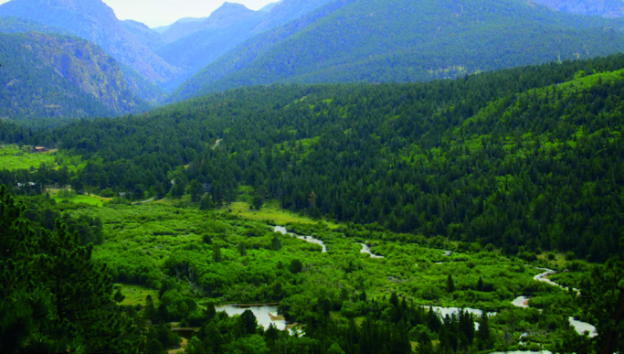
Water is the reward on this trail. Not only is Sandbeach Lake one of the deepest natural lakes in the park, but the trail follows segments of two streams: North St. Vrain Creek and Hunters Creek. The initial section of the hike offers expansive views of the North St. Vrain’s headwaters—a slow, meandering build-up before the stream enters a steep-walled canyon to the east. And just as the sweat spot grows between your back and backpack, the trail meets and eventually crosses Hunters Creek, a fast-flowing mountain stream inhabited by federally-protected greenback cutthroat trout.
Do:
Both streams have flow protections. In 1995, the Colorado Water Conservation Board (CWCB) appropriated an instream flow water right on all 4.6 miles of Hunters Creek for flows varying from 0.75 cubic feet per second in the winter to 3.5 cfs during runoff. Today, new water users cannot deplete those minimum flows. Just downstream of the park boundary, the North St. Vrain enjoys protections of up to 21 cfs under two water rights owned by the CWCB. The CWCB is the only entity today that can appropriate or acquire water rights for instream flows, and the agency protects more than 8,000 miles of streams in Colorado. These instream flow water rights have equal footing to every other water right in Colorado and are administered by the state according to their relative priority under the “first in time, first in right” system. Trekkers can also see the headwaters for many other well-known rivers in the park, including the Colorado and the Cache la Poudre. Although the two rivers’ headwaters begin less than 2 miles apart, the Colorado runs west, carves the Grand Canyon, supplies 30 million people with water, and flows toward the Gulf of California. On the other side of the divide, the Poudre flows down to Fort Collins, joins the South Platte River near Greeley, and eventually reaches the Gulf of Mexico. Both rivers have protected instream flows for particular segments.
Act:
Find out if your favorite local stream has flow protections on the Colorado Water Conservation Board’s website at www.cwcb.state. co.us. Click on Instream Flow Program, and search the database by county, water division or watershed. If the stream does not currently have protections, you can recommend a new appropriation by filling out a questionnaire: www.cwcb.state.co.us/environment/instream-flow-program/Documents/Appropriations/ISFQuestionnaire.pdf. If you own senior water rights, they can also be sold, leased or donated to the program. Contact the CWCB or the Colorado Water Trust, a nonprofit that specializes in water right transfers for instream flows: www.coloradowatertrust.org.
 Print
Print